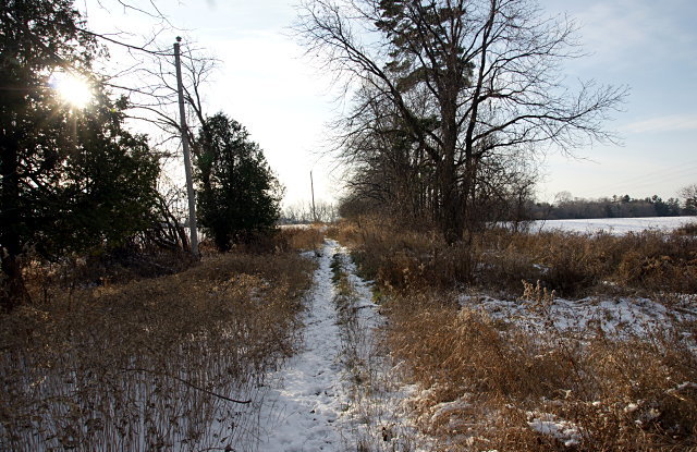
 Passmore Avenue looking west from west of Beare Road.
If you’re familiar with Passmore Avenue in Scarborough at all, it’s probably as an unremarkable industrial street that runs in two discontinuous sections between Kennedy Road and Markham Road. But along with the rest of the concession roads in Scarborough, it long predates suburbia: it was laid out and cleared in the 1800s. On an 1878 map, Passmore (then known only as Concession Road 5) stretched 14 km clear across the township of Scarborough with only three short sections missing where the road would have crossed the Rouge River. More modern maps and aerial photos show that Passmore remained a country road crossing Scarborough well into the 1960s, when portions of it started falling to suburban development or neglect.
Although the Passmore name has virtually disappeared over the last 50 years as Scarborough grew from farming township into a suburb, most of the original route still carves its way through the former borough. West of Markham Road, the original road allowance is given over to portions of more than a dozen different suburban roads and park pathways that trace the old road, starting with Gordon Baker Road in the west and continuing to Ketchum Place near Middlefield Road. Drivers can’t follow the entire road thanks to all of the twisty-weavy suburban streets, but multi-use paths directly connect the whole route (except for one block) to allow a continuous 8 km long suburban walking or cycling tour along the old right of way from Victoria Park Avenue to beyond Markham Road. There’s no physical evidence of the original road here other than the straight route through the heart of suburbia.
East of Markham Road, Passmore was never much more than a dirt road through the countryside. Except for three very short half-blocks that still exist, most of it no longer appears on maps and has dropped off the municipal street grid. Yet the old road allowance remains largely open to intrepid hikers in this rural corner of the city. The most accessible portion of Passmore Avenue runs between Gordon Murison Lane and Beare Road, where a line of utility poles stands guard over the old dirt road as it dips into a small valley, passes farm fields on either side, and crosses a small tributary of the Rouge River before climbing back up a low hill at the other end.
A partial tour of the eastern half of Passmore and more photos are below the fold.
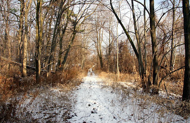
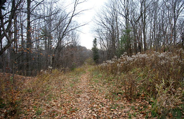
This picture was taken a few steps from the one at the top of the article, but facing east toward Beare Road. A small tributary of the Little Rouge River passes under the road in a culvert in the middle foreground of the picture.
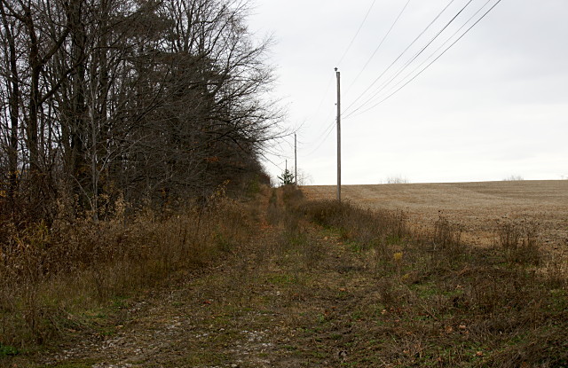
Looking east from near Gordon Murison Lane. Utility poles still line at least two long stretches of the Passmore road allowance. Of all the abandoned sections, this is probably where the road is most easily identifiable as more than just a path through the woods.
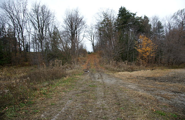
Taken from roughly the same spot as the previous picture, but facing west instead of east. The road here appears to be well-used by farm vehicles accessing the adjacent fields. Just above the hill in the centre of the picture is a little half-block of Passmore at the bottom of Gordon Murison Lane. The 1878 Township of Scarborough map shows that the farm to the south (left) of the camera was owned by William Murison, while Benjamin Reesor was to the north (right). The Reesor family has farmed in this area since 1804, and still does. And here you thought that Scarborough wasn’t invented until 1953.
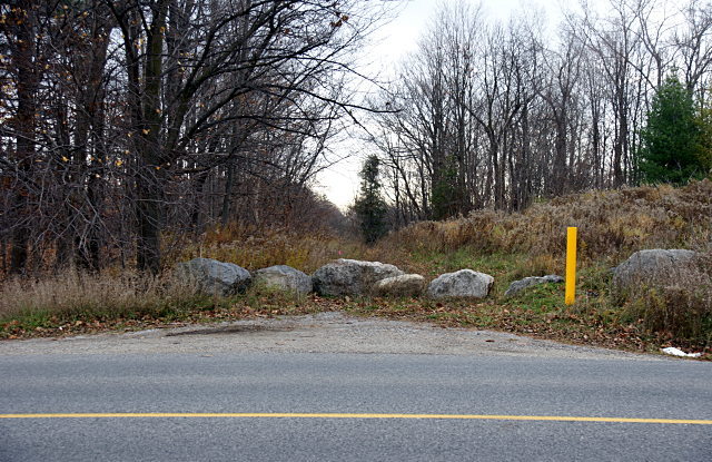
At Reesor Road, vehicular access to the old road is blocked by a row of rocks.
East of Reesor Road, Passmore descends into a valley in Rouge Park, where it forms a portion of one of the walking trails. The city’s maps of this spot show the park cut into three pieces by the east-west road allowance for Passmore and the north-south allowance for Gordon Murison Lane south of Passmore.
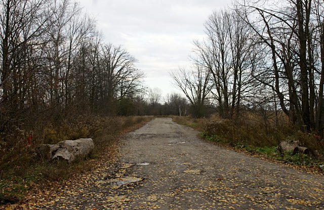
Looking east toward Littles Road, this is one of few sections of Passmore east of Markham Road that is still called “Passmore Avenue” and shows up on modern maps. This stretch west of Littles, another west of Beare Road, and Littles Road between Steeles and Passmore are the only city-maintained dirt roads that I know of in Toronto.
Passmore isn’t the only “lost road” in the picture above; maps show that an allowance for Littles Road continues for approximately 1.5 km south of Passmore. If Littles continued south from there, it would match up perfectly with Morningside Avenue. Allowances for two other roads also still exist nearby. Not too far behind the camera, an unnamed city park lurks in the middle of the woods. The stretch of road pictured above also appeared at the top of a previous Dodgeville post.
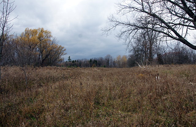
Southwest of the intersection of Littles Road and Passmore, a former horse farm is now a small part of Toronto and Region Conservation‘s land holdings in the area. Although it looks like an overgrown meadow from the ground, the oval horse track remains clearly visible on current aerial photos and Google Maps. The track was first built in 1966 and maintained until the late 80s. By 1992, it had been abandoned and looked much as it does now. The ruins of three farm buildings and a silo remained on the site until 2002.
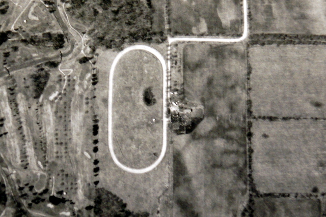
A 1989 aerial shot of the farm, with the Passmore and Littles intersection at the top right, shows an immaculate track and manicured infield. The stand of trees in the infield still exists today and appears in all of the aerials I examined going back to 1950.
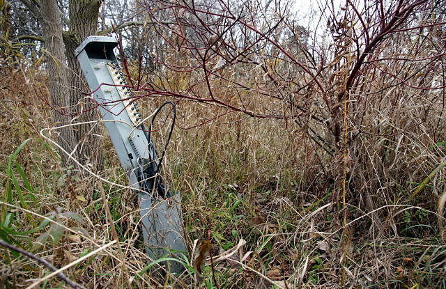
This old telephone connection box was the only evidence I could see that something more than an empty field used to be here. I’d like to go back in something other than cycling shoes next year and see if I can find the foundations of the old buildings. According to my GPS and aerial maps, I was almost right on top of them at one point. It took three cycling trips to the farthest reaches of Scarborough and one to the Toronto Archives, but exploring Passmore sure was fun.
Most of the Passmore Avenue road allowance east of Markham Road lies within the boundaries of Rouge Park and is protected from further development. It will probably continue to be eaten away by TRCA’s ongoing efforts to renaturalize more of the park.
A version of this article originally appeared on Torontoist.
Wonderful post Val.
I’ve walked the portion of this that is in Rouge Park, East of Reesor.
However, at the time I walked it, I didn’t make the connection to Passmore.
I was merely thinking ‘old farm lane’.
This gives me a whole new way to see this area the next time I hike the north end of Rouge Park.
Yes, another great entry in the “I’ll have to find this place myself” book you seem to be writing for me :-).
My wife and I are always looking for new places to hike in Toronto. Might have to wait for spring if we get as much snow as last year, but even in the winter this looks like fun.
I have a question…
Do you know who Passmore Ave was named after? and why?
I’m doing a family tree and I heard this street was named after a distant relative of mine.
I don’t know who it was named after, but old farm roads like Passmore were frequently named informally after farmers whose land they bordered (as in, “the road to Reesor’s farm” eventually becomes “Reesor Road.”). I can’t say for sure whether that’s the case for Passmore, but someone at the Scarborough Historical Society would probably be able to help you with the origin of the street name.
Thank you very much!
prior to the 1950 we lived at warden and passmore ave with a postal address of
rr#1 milliken but prior to that the name was GORE rd
Passmore may have been named after F.F. Passmore, a surveyor from Toronto, who was hired to re-survey Scarborough in the 1960’s.
http://www.ourroots.ca/page.aspx?id=958497&qryID=5fb6b164-0824-4759-ab49-bf9174ceca27
I miss Passmore Road…
F.F. Passmore was a surveyor as you indicated but he surveyed Scarborough in 1860s not 1960s.
I saw the article in The Globe and Mail. I lived on the western section of Passmore from Kennedy Road going west. We had ten acres on the north side. Our neighbour at the bottom on our 1/4 mile driveway the Purcell Pony Farm. I lived there in the mid 1950’s to the early 1960’s when we moved back into the city. I think my mother was tired of the isolation of country living. They did keep the big house and the land until it was sold to Hugh Heron of Heron Homes sometime in the 1970’s and he built a suburb there.
When we lived there the road was paved but a typical narrow country road. There were farms all around us and the next road to the north was Steeles. Passmore only went as far as the next north/south road (which I cannot remember the name of but it still exists and is a major road now) and ended in fields that we used to explore.
Joan
Thank you Anna F.F Passmore was my Great Grandfather
Wow, interesting I found this post exactly one year after written by randomly looking up this lonely road named “Gordon Murison”. (Quite a few in NE Scarborough!) I have always been wondering about this street. Thankfully you wrote about it!
What a great find. Found by searching Gordon Murison. Have been intrigued by the area’s past since discovering Google Earth and geocaching. Am currently reseaching anything to do with rail trails and their link to the past. Thanks for the Passmore history.
Just visited Littles rd. and Passmore Ave. today. I went last year and thought it would be great to see it again. Took some pictures this time. I actually went down what was once the road way to the race track. The track seemed to be quite visible, however, there is lots of greenery on it now. Excellent post here, Val. Would be great to see a follow-up to this one.
I’m looking for farm history or any history of my grandfather Frank Sterba, lived in the Toronto Middlefield road until 1983. He lived with his mexican wife Maria Veronicia Stupka. Please, if you have some picture or memory of Frank Sterba, will happy if you contact me. Thank you Roman Cech
Hi,
It is interesting to read these posts. Passmore ave east of Markham road is now gasping its last breath. There is a new sub division that has come up on Passmore and Oasis. That end of Passmore has now been dug up and soil is being trucked to maybe naturalize this part. So this seems to be the end of this section. However, I saw a new intersection being developed just west of the railway tracks. So I guess maybe Morningside Heights may be extended to meet here.
This section of Passmore will be no more.
This is true. Almost 9 years later, and Passmore is totally naturalized, and deadended to meet the back wall of the new Amazon distribution centre. no new intersections were developed since, besides a traffic light being installed at Tapscott and Steeles. I think the last remaining stretches of Passmore will be solely industrial use now. I really hope it doesn’t take away the only four way stop on a busy roadway(Tapscott/Passmore).
I visited the section next to the new Amazon building today. Last time I was there in 2010, there was a road extending south toward Morningside. Now it’s blocked off by rocks, and it’s amazing how much it’s grown over since it was…abandoned? Closed off? Dug up? I’m not sure what happened to it, but now there’s no road between that point and the train tracks.
Passmore Avenue was named after my 2nd great grandfather.