Scarborough's Tower

Many cities around the world have their own versions of the CN Tower. Seattle has the graceful Space Needle, Calgary has the creatively-named Calgary Tower, Rotterdam has the squat Euromast, and even Niagara Falls has the Skylon. Yet despite the best efforts of all of the imitators, several of which are such fierce competitors that they copied our own CN Tower years before it was even conceived, none of them are quite as towery as the original.

But I didn’t realize until I rode by the other day that Scarborough also has its own version of the CN Tower near Lawrence & Galloway:

Scarborough Tower

It’s not quite as grand as the others and it lacks a revolving restaurant, but it makes up for those shortcomings with a healthy coating of rust and a certain suburban je ne sais quois.

I frequently see antennae of various descriptions perched atop water towers, but this is by far the largest such specimen that I’ve encountered.

Two things you don't see every day

1) Canoeists on the Don River:

Paddling the Don, May 2007

2) A cyclist crossing the DVP (and not getting killed in the process):

Cyclist crossing the DVP

Both of these pictures were taken at about the same time, looking north from the Queen Street bridge. The first was made possible by the annual Paddle the Don event. The second came courtesy of the weekend closure of the Parkway. This guy had actually been riding northbound (in the southbound lanes!) but was chased  over the barrier and off the highway by a works crew that passed him a few seconds before I took his picture. Hey dude! The Ride for Heart is next month.

Ward 29 Environment Day

Today was the Community Environment Day in Ward 29, brought to you by Councillor Case Ootes. It’s the first time I’ve been to the event in this ward, having lived in neighbouring Ward 31 until a couple of years ago.

I wanted to make a point to Councillor Ootes, so decided to take my load consisting of several old cans of paint, a number of expired batteries, a dozen ink jet cartridges, an old cell phone, and a bucket of used syringes (courtesy of my diabetic cat) to the event by bike. This would be especially easy for me since the drop-off point was directly accessible from Ootes’s pet project, the Cosburn Ave bike lanes. My decision was also helped by the fact that Risa was out with the car today.

I planned to drop off my stuff and then track down Ootes to get the typical “smiling politician” picture of him with my bike.

So I loaded up my trusty BOB Yak trailer and set out.

My BOB Yak loaded and ready to go

I arrived at the Environment Day drop-off about 10 minutes later, and several cheerful employees helped me unload all of my goods. I then set out to look for Case Ootes, but couldn’t find him. No one I asked had seen him either. If he’d been there at all, it was probably just long enough for a photo op.

So much for my plan. And so much for the picture of Ootes propping up my bike that was supposed to accompany this blog entry.

Was it unreasonable to expect to see him there? Do other councillors attend (and stay at) their Environment Days to schmooze with their constituents? I guess I was spoiled by my attendance at Janet Davis‘s Community Environment Day in Ward 31 in previous years. Not only was she there, but she also had live music and other amusements to create a friendly atmosphere. No such luck in Ward 29, unless you count the Tim Horton’s tent and the free hot dogs (sold out by the time I got there at noon).

Bike lane ticket

At the end of a post a few weeks ago, Torontoist’s Marc Lostracco unveiled a flyer (PDF) for cyclists to stick under the windshield wipers of cars parked in bike lanes.

Not to be outdone, Spacing’s Matt Blackett released a poster he’d designed last year, chiding motorists for the same offence.

The notice (PDF) available on youparklikeanasshole.com doesn’t have a specific option for drivers that park in the bike lane, but I like it anyway.

All of this reminded me that I’d picked up a fistful of these double-sided “tickets” outside the Cycling Committee office at the East York Civic Centre last year.

A parking ticket for bike lane offences

I keep meaning to ticket some bike lane parkers — especially along Queens Quay, where I rarely ride the 200 metres from Bathurst to Stadium without having to dodge at least one parked car — but always forget to put a few of these in my gear bag before I leave home.

Some variation of these tickets has been around since at least the summer of 1996, when they were mentioned in the July/August 1996 Cyclometer. I assume that some are still available at the East York Civic Centre, and probably at other locations as well.

Bike lane on Steeles

A bike lane appears on Steeles Ave. East

One of Toronto’s odder bits of cycling infrastructure sits in the very northeastern corner of the city. With farms lining both sides of the relatively sleepy four-lane Steeles Avenue, the pavement widens and a bike lane takes up residence on the shoulder. Starting just west of Beare Road in Scarborough, the lane runs less than a kilometre east to the Scarborough-Pickering boundary before ending as abruptly as it began.

I didn’t even realize until I consulted the bike map after I got home that this little stub of a lane was even connected to any part of the bikeway network. It seems that there’s a signed route running down Beare Road from Steeles that I didn’t notice when I passed. I wonder how many people actually ride in this lane. I suppose there may be a few commuters and some weekend riders out to explore this underappreciated corner of the city, but the lane would make much more sense if it extended a few kilometres west.

Toronto’s Bike Plan (PDF, page 5) indicates that this abbreviated lane will meet up with the Steeles bike lanes at Markham Road in the future, eventually extending as far as Pharmacy. Markham proposes (PDF) two bike lanes that would connect to this section from the north. I can’t find anything about proposed bike lanes in Pickering.

I’m happy to see bike lanes on any stretch of road and these ones do provide a somewhat tenuous cycling link to Whittamore’s Farm, but they seem quite out of place at the moment.

Offroad streetcar

An old PCC in Pickering

I always hear about old streetcars sitting out in farmers’ fields or doing duty as storage sheds in the middle of nowhere, but I’d never seen one for myself until this past weekend. This one is on Finch Ave in Pickering, just east of Scarborough-Pickering Town Line.

I would have gotten in closer for some pictures, but the place was plastered with ‘no trespassing’ signs and there was no one around for me to ask about it. I assume that they’re tired of having transit and photo geeks crawling all over their property, but what do they expect with a rusting old PCC sitting in their front yard?

From farm to suburb

One of the wonderful ways to pass an afternoon at the Toronto Archives is browsing through the aerial photographs of the city. You get a real sense of how the city grew from year to year, swallowing productive farmland at virtually every step.

The photos here show the relentless march of progress in a section of the city around York Mills Collegiate.

1950

York Mills & Bayview, 1950

It’s still all farmland in 1950. The main intersection at the left is York Mills & Bayview. That’s Wilket Creek flowing through the intersection. York Mills Collegiate will soon be built at the right side of the picture, in the farm field directly north of the little half-circle driveway on York Mills.

Read More …

Bucket man

I fulfilled a lifelong fantasy yesterday and rode a bucket 45 feet into the air. York Mills Collegiate, where Risa teaches, was doing an outdoor photo shoot to mark their 50th anniversary and the official photographer was running late. As the husband of the event organizer, I was quickly drafted to stand in a basket at the end of a really long pole.

Looking straight down the boom that’s holding me aloft

That’s my new best friend Ian three storeys below me at the bucket controls.

1,100 York Mills students prove that high schoolers really can spell

All of the students gathered on the field behind the school to spell out the York Mills initials, paying homage to a similar image taken 20 years ago for the 30th anniversary. Risa is one of the few to be in both pictures — the first as a student, the second as a teacher.

I’m glad it wasn’t very windy.

Naturally, I made Risa take pictures of me up in the bucket after my official duties concluded. Weee!

Ghosts of the Martin Goodman Trail

The forgotten Martin Goodman Trail in the shadow of the Gardiner Expressway

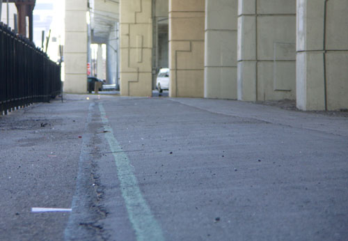
I rediscovered the mostly-forgotten northern portion of the Martin Goodman Trail quite by accident last summer. I was stuck in a surprise downpour while riding along Queens Quay and scooted up to Lake Shore to hide under the Gardiner for a few minutes. And there they were, the familiar blue and green lines marking the original alignment of the Martin Goodman Trail.

I rode along and was quite surprised at how much of the original trail remained despite more than 15 years of encroachment by condo projects and neglect by the city. I was able to ride from York Street to Stadium Road without interruption, even though one section of the trail has been co-opted for a condo building’s back lawn.

The forgotten Martin Goodman Trail runs into a condo's back lawn near Spadina

I started cycling this portion of the trail regularly again this spring and met with another surprise: riding along here can be a lot faster and easier on the nerves than riding along Queens Quay. Not only is there less traffic to contend with, but the traffic lights usually favour traffic along Lake Shore rather than the intersecting streets. As a result, you can frequently zip from York Street to Stadium Road with only one or two brief stops for cross traffic. No more stopping for red lights at every driveway and parking lot along the way.

Old-timers like me will remember that the downtown section of the trail was always a bit of a puzzle. The original westbound alignment had you crossing from the south side of Queen’s Quay near Sherbourne to the north side, continuing along the north side to York Street, sometimes on the road, sometimes on a marked section of the sidewalk. You turned north on York and continued riding beside Lake Shore Boulevard all the way past the pre-loft Tip Top Tailors building and HMCS York driveway before swooping into Coronation Park.

Going east, cyclists were expected to ride on the north side of Queens Quay until Sherbourne, and then cross back to the south side before picking up the off-road portion of the trail again.

The various north-south transitions were so poorly designed with zero traffic control that most cyclists eventually ignored them completely and rode straight along Queens Quay for the entire distance.

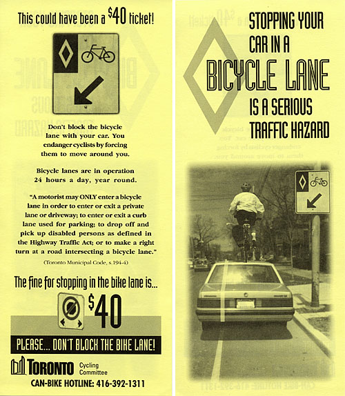
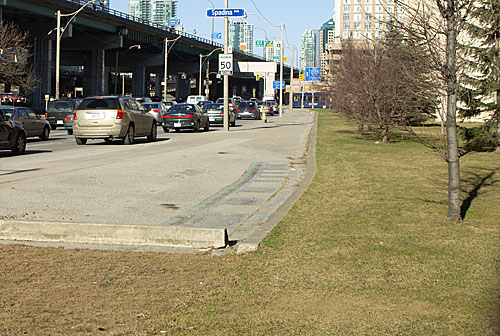
The city eventually acknowledged reality and redesigned both ends of this stretch. The eastern portion of Queens Quay got proper directional bike lanes along each side of the street between Parliament and Yonge, and the western end got bike lanes from Spadina to Stadium Road and a direct connection behind the Tip Top building to the off-road trail.

With the extremities fixed, the middle seemed to fade bit by bit. The trail on the north side of Queens Quay east of York was repaved at some point and the distinctive blue and green trail markings were left off. Signs pointing to the continuation of the trail a block north disappeared. The trail beside Lake Shore was degraded one section at a time by adjacent construction. Eventually, memories faded with the paint and the trail just seemed to stop at Yonge and resume again at Spadina, with nothing but a stressful ride along Queens Quay in between.

The original alignment was never beautiful and was only barely functional. Sadly, it was and remains better than the current alternative. The upcoming Queens Quay redesign (previewed as Quay to the City last summer) should go a long way toward finally fixing this section of our waterfront trail.