Guelph to Kitchener

The road from Guelph to Kitchener

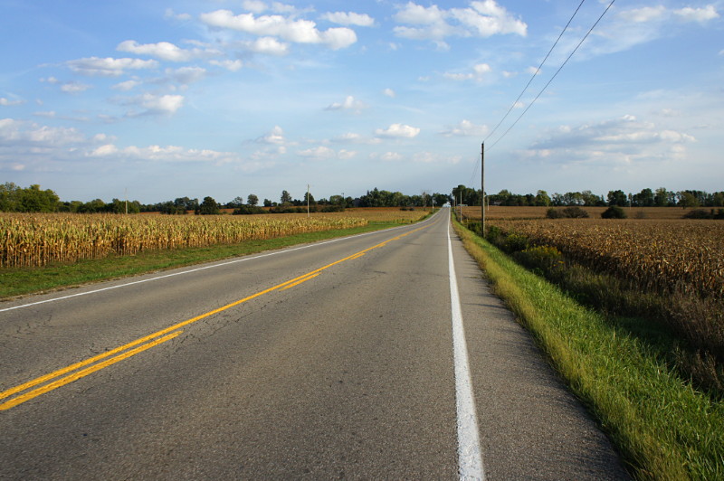
The farm-lined road to Anywhere, southern Ontario.

First, a travel tip for anyone taking a bike into the York Mills GO terminal: the canonical way to get to the bus platforms is to go into the York Mills Centre at the northeast corner of Yonge and York Mills, take the well-hidden elevator up to the second floor, and then walk down a short flight of stairs. It’s not so bad on foot, but it’s an overly complicated two-step when you’re swinging a loaded bike around. It’s way more convenient to ride just a few more metres north up Yonge to the same portal that the buses use and ride in through that as if you owned the place. It’s not only a shorter and easier route to the platform, but it means you don’t have to shoulder your bike down stairs or make everyone in the elevator miserable. It’s also far safer. You won’t be riding into a fare-paid zone, so it’s not like you’re doing anything underhanded.

I made a multi-modal trip to Kitchener this weekend (I’ll write more about that in the future), taking GO Transit to Guelph and cycling from there to Kitchener on Friday morning, and then reversing the trip on Sunday evening. Riding the roughly 28 km from Guelph to Kitchener is unlike riding in the countryside anywhere near Toronto. Oh sure, you’ve got the same corn fields, roadside ruminants, sod farms, rural communities, and quiet country roads, but the terrain is remarkably flat. There were only two noticeable hills for the entire ride and even those were smaller than climbing up Danforth from Coxwell to Woodbine. I’m used to traversing the Oak Ridges Moraine or climbing hills on hills on hills in the Peterborough drumlin field when I ride in the country, so riding somewhere flat is quite a treat.

Highway 7 provides the shortest and most direct route between the two cities, but it’s not very pleasant to ride on. A more southerly route along Wellington 124 is about 5 km longer but it’s at least 10 km nicer to ride on. I took a middle way to Kitchener that had theoretical advantages over taking 124: the route along Fife Road is both quieter and shorter by almost 3 km. It also has a long stretch of riding on dirt roads, which doesn’t usually bother me. It would have been perfect if I hadn’t been riding in Friday’s rain, which begat mud, which begat a poorly functioning drivetrain, which begat sucking the fun out of the ride. I was insanely happy that my hotel room was ready three hours before check-in time. “How are you today Mr. Dodge?” “A little muddy.” “I see that.” In total, the ride from downtown Guelph to downtown Kitchener was 28.5 km and took 90 minutes in the rain with a malfunctioning rear derailleur that left me more or less stuck in an awkward gear.

Sunday’s evening’s return trip was sunny and warm (see the picture above) with a steady tailwind. I took advantage of the tailwind to ride the slightly longer return route along Kossuth Road and Wellington 124. Both of those roads have nice wide paved shoulders for most of their length and are easy to ride on if not quite as scenic as some of the quieter rural roads. The return trip was 30.5 km in just 75 minutes with a tailwind blowing all the way. Not bad for a loaded mountain bike. I’d recommend the Fife Road route if it’s dry and you don’t mind riding on dirt roads. I don’t think I’d do it on my road bike. If you want a smooth ride that’s relatively fast but with less traffic than Highway 7, take Wellington 124 and Kossuth Road. You’ll have to head either north or south to cross the Grand River into town; take whichever way is the shorter route to your ultimate destination.

If you’re so inclined, you can read a more detailed ride report below the fold.

Read More …

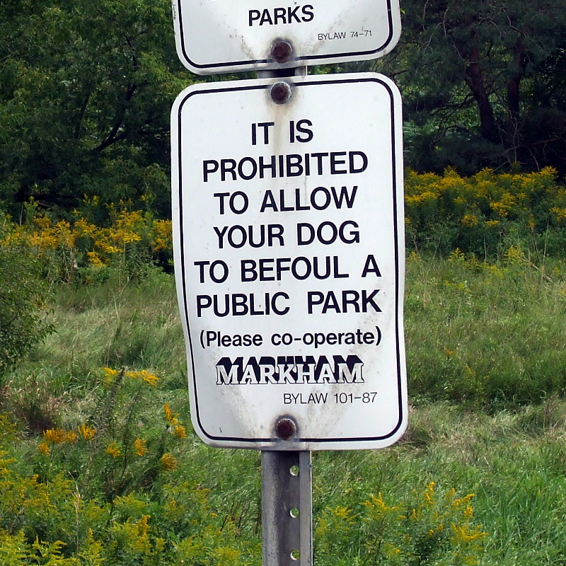
No public befoulment

No park befoulments allowed in Markham.

Markham sets down the rules about park befoulment.

Oh, Markham. I can’t even count the ways I love this sign. Start with the peculiar wording (“It is prohibited to allow”), work in an odd euphemism (“befoul”), continue with a parenthetical plea for cooperation, and wrap it up by citing a long-obsoleted by-law. And if that wasn’t enough, you top it all off with “Markham” written in that 3D typeface straight out of the ’80s. That’s a whole lot of awesome packed into a simple “stoop and scoop” sign.

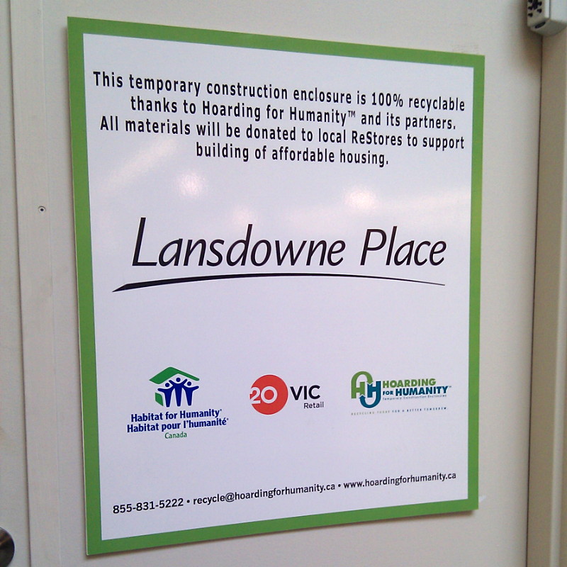
Hoarding for Humanity

Hoarding for Humanity

“Hoarding for Humanity” sounds like a joke at first, possibly yet another depressing show exploiting people with psychological problems on formerly-good channels like A&E or TLC. Yet there’s the sign, staring at me from the hoarding in the mall, all but begging me to make fun of it.

It turns out that Hoarding for Humanity really is a thing, an offshoot of Habitat for Humanity that sees construction hoarding reused instead of being tossed into the landfill. Locally, the Scarborough Town Centre and Square One malls are participating in the program.

Love the concept. Love the name even more.

The scent of a blogger

Blog pour homme eau de toilette

Now you too can smell like a real blogger without all the effort of sitting in a chair and typing.

If you’ve ever wanted to smell like a blogger (and honestly, who hasn’t?), your wait is over thanks to Shirley May’s newest budget-conscious fragrance, Blog pour homme. Sorry ladies, no Blog for you! Joining Shirley May’s signature men’s fragrances Hunk, Army Fight (your very own chance to smell like napalm in the morning!), and Obama, Blog’s blend of “rosemary, Artemisia, lavender, basil, lemon verbena, bergamot and lemon” is the olfactory equivalent of snark, humour, bemusement, passive aggression, cycling, and love of signs.

Public bike repair stands

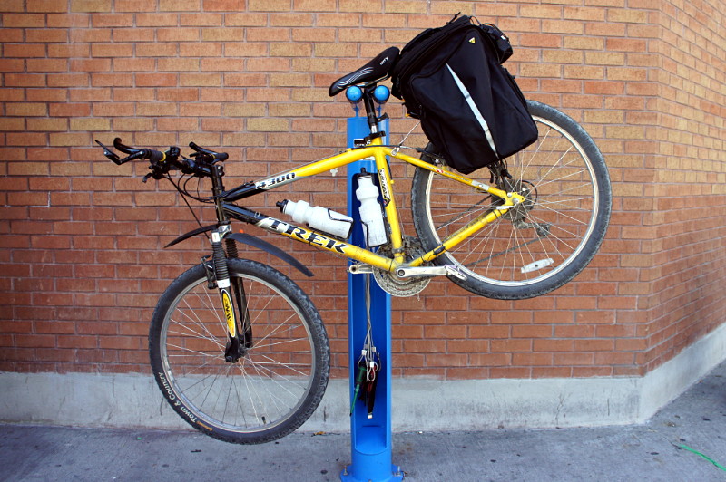
I was riding downtown a couple of weeks ago and decided to pop my bike up on one of the newly installed public bike repair stands to give it a quick once over:

Old Faithful on a public bike repair stand.

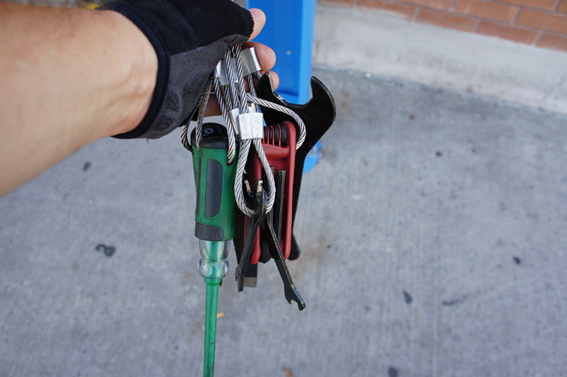
Each of the three stands downtown (plus one more on the university campus) includes a full set of tools for most basic on-the-go repairs and adjustments:

Tools available at the public bike repair stand.

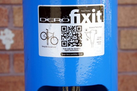
The stands even feature bike repair videos and tips, via a QR code that links to a helpful website.

QR code for bike maintenance instructions on the public repair stand.This is the kind of cycling infrastructure that I love: it’s incredibly useful for both casual and seasoned riders and just sits unobtrusively in the background until it’s needed. The only thing missing from the stand is a pump, which is probably the one tool that would be used the most. Susan Sauvé, a transportation planner at the city, told me via email that pumps were originally included with the stands when they were installed in July, but they all broke within a week. The city currently has more durable pumps on order from the manufacturer and hopes to re-install them soon.
My bike checked out fine on this occasion, but I definitely could have used one of these stands when my pedal broke near Grange Park last year and I needed to conduct some emergency repairs before finishing my commute. It’s good to know that if it happened again today, I’d be just a short 163 km ride away from this stand at the corner of George and Simcoe Streets in downtown Peterborough. The two other downtown Peterborough locations would be a smidge closer, and the one at Trent University a bit farther. The stands were installed this summer through a partnership of the City of Peterborough and B!ke, a local DIY bike repair shop. Oh, you didn’t think these were in Toronto, did you? Doncha know there’s a war on the car here? The last thing we want to do is make things easier for those dastardly bikers.

Peterborough to Hastings rail trail


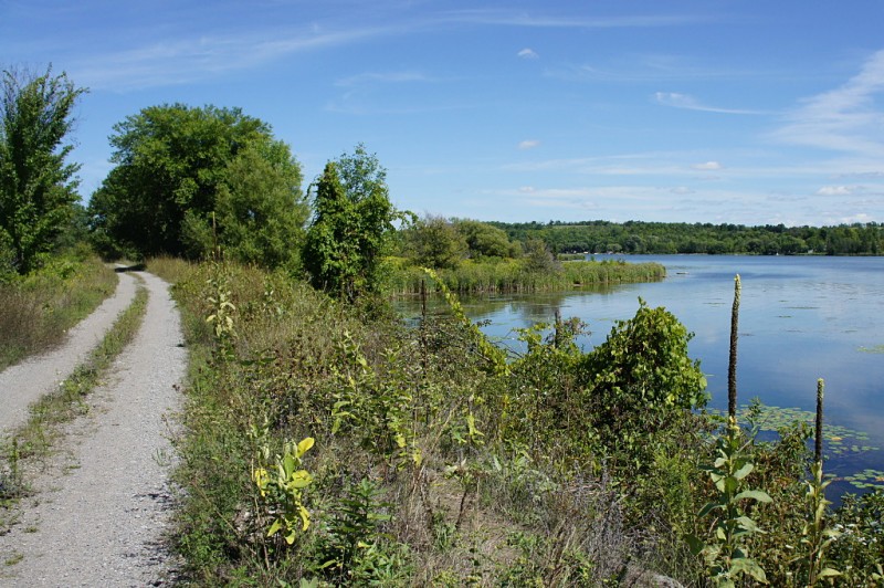
The Peterborough to Hastings rail trial curves away from the Trent River after kissing the shore.

After our thoroughly enjoyable trip on the Peterborough to Omemee rail trail a few weeks ago, I decided to take a trip down a second Peterborough-area rail trail this weekend, heading east out of town this time. Risa was unable to join me for the ride, so I packed up my day-trip kit and did this one solo.

The Peterborough to Hastings rail trail is not yet part of the Trans Canada Trail, but is listed as a proposed addition and there is some work afoot to make it official (PDF) and make improvements where necessary. As it stands now, the trail is formally maintained only in winter as a snowmobile trail, leaving summer maintenance to volunteers acting on an ad hoc basis with no coordinating body.

Compared to the Peterborough to Omemee trail, the lack of coordination shows: the route to Hastings is a little more wild and a bit more of a challenging ride. Unlike the smooth wide bed of gravel dust on the Omemee trail, the ride to Hastings is mostly on dirt double-track with some large gravel, loose sand, and other trail hazards along the way. Some of the bridges seemed to be in rough shape, with some surface planks rotting away and exposing holes big enough to see through to the rivers below. The trail is probably smooth as butter when it’s covered with a couple of feet of hard packed snow but it can be a little jarring on a bike in the summer. It’s certainly in good enough condition and offers enough variation for an average cyclist to have an enjoyable trip, but you won’t find any beach cruisers on it. Front suspension on my mountain bike was most welcome by the halfway mark.

The trail was exceptionally quiet considering that it was a beautiful Saturday afternoon for cycling or hiking. The first 90 minutes of my two hour putter along the trail were blissfully solo, without another soul in sight at any time, even when crossing intersections. The last half hour was almost as quiet and I only encountered four people on the trail before I turned onto the streets of Hastings. I imagine that it’s not quite as tranquil when the snowmobiles hit the trail, but it’s a very relaxing summer day trip.

The trail ends somewhat unceremoniously in the middle of the Trent River in Hastings (see the gallery below for more information about that), but you can make connections from there to other trails that continue to Campbellford, Tweed, and Sharbot Lake. Traversing gaps to yet more trails that can get you as far as Bancroft or within hailing distance of Bon Echo Provincial Park.

The Peterborough to Hastings rail trail starts approximately 7 km southeast of downtown Peterborough at Keene Road and runs about 29 km to Hastings. Like most rail trails, it’s fairly flat and grades are slight enough that they won’t trouble even the most casual of cyclists. The scenery ranges from wide-open farmers’ fields to thick forest growth and includes views of numerous rivers, creeks, marshes, swamps, cows, and even a couple of trailer parks heading into Hastings. Intersections are mostly quiet dirt roads. There are no obvious supply facilities or rest stops along the way other than farmhouses that back onto the trail; the village of Keene is about 2 km south of the trail at the 9 km mark, but that’s about it. Be sure to pack a repair kit and adequate food and water.

Check out the gallery after the jump for the usual ride pictures and commentary.

Read More …

Todd Morden Mills

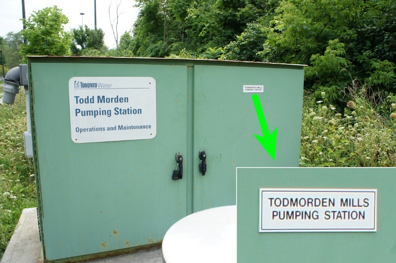
It’s a pretty remarkable coincidence that just a few steps from Todmorden Road in Todmorden Mills in the Todmorden neighbourhood of East York—all of which were named after Todmorden, England—is a pumping station named after someone called Todd Morden:

Todd Morden pumping station sign


Now you might think that this is just another careless spelling error, but Google tells me that there really is a Todd Morden, and he’s this guy:


Google can’t tell me why he has a pumping station named after him, but I’m sure he deserves it.

And just in case you still think it’s merely a spelling error, I can assure you that although there is a Todmorden Mills pumping station, it’s a completely separate facility. In yet another remarkable coincidence, the two pumping stations share a single cabinet:

Mind you, I’m just assuming that these are two separate facilities and that surely the City of Toronto wouldn’t misspell the name of one of its heritage properties on a prominent sign inside that property. And surely workers tacking up the sign would have sent it back to the sign shop with a note as soon as they noticed the error, instead of just blindly posting it. Right?

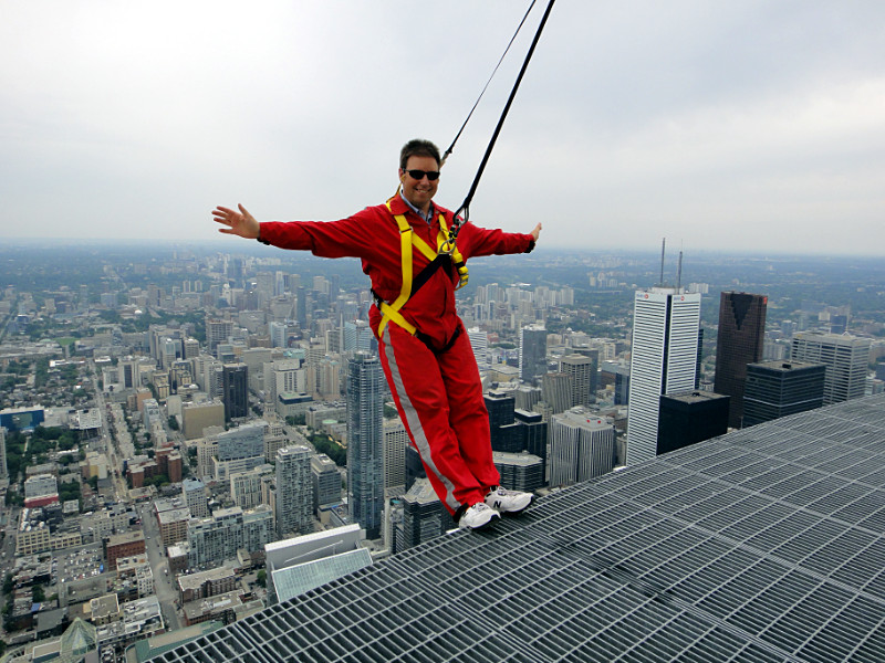
‘sup? Just hangin’.

The rigging is checked twice by each of two different people. The harness is double-checked by each of three different people. Even your shoes are checked twice to make sure they’re on tight. You have to pass a breathalyzer test, get frisked with a metal detector, remove all jewellery and personal items, and be swabbed for explosives and narcotics. By the time you step outside onto the 1,168-foot-high walkway, you’d probably be in more imminent danger if you were swaying in a hammock reading a book. Yet casually leaning over the edge of the CN Tower requires your still-unconvinced brain to override your body’s instinctive resistance in order to push your centre of gravity out beyond the relative comfort of the walkway. After all, the next step down the staircase is a ten-second freefall away. By the time you’ve done it forwards and backwards and get around to posing for pictures, it’s almost second nature. Almost.

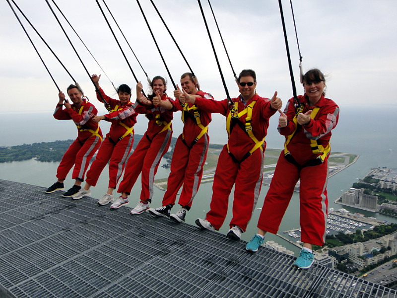
Right to left: Felicity, Val, and four other people with nothing to do on a Thursday afternoon.

So Felicity and I went on the CN Tower EdgeWalk last week. The walk itself takes about 30 minutes to circumnavigate the Tower on a 150-metre-long track, with nothing between you and your view of the city but the weather. The whole experience starts about 30-45 minutes before you step outside with the signing of the waiver, the donning of the red jumpsuit, and undergoing the aforementioned security and safety checks. Most of these preparations take place in a glassed-in room just off the gift shop at the base of the Tower, allowing a disbelieving public to watch six people calmly preparing for a short urban stroll. When the harnessed and jumpsuited walkers stride out of the prep room toward the elevator, staff and onlookers applaud and cheer. You can’t help but feel like a dorktastic version of the Mercury 7 strutting down the passage to the admiration of all and expectation of glory to come.

In addition to just walking around the deck and seeing the sights, the guide takes everyone through a series of exercises: stepping your toes over the edge, leaning backward, and leaning forward over the abyss. Then it’s picture time and you’re back inside almost before you know it. The funniest thing about it is that walking on the outside of the Tower quickly comes to seem so normal that all of the locals start doing what they usually do whenever they go up to the observation deck with out-of-town friends: they trace streets and scope landmarks, trying to pinpoint their houses somewhere below. I got as close as an apartment building on my street. The EdgeWalk is an expensive way to spend the afternoon, but it’s worth every loonie. I highly recommend it unless you’re completely jaded. And then I’d recommend it just to restore your sense of fun.