Three and a half hours after setting out from home on Sunday, I was rolling up to Willow Beach on Lake Simcoe. It’s pretty underwhelming as beaches go, but that didn’t stop me from celebrating by taking my shoes off and wading around in the cool water while I ate my lunch. The ride back home was into a full-on headwind, destroying the usual downhill advantage of the ride back to Toronto. This was the third time I’ve tried this trip this summer. The first time I turned around after an exhausting traversal of a muddy, overgrown trail, but I wasn’t really expecting to make it all the way up that day anyway. My second attempt was cut short by time constraints just 20 km from Lake Simcoe.
It wasn’t the first time I’ve ridden up to Lake Simcoe, but it was the first time that I’ve gone all the way up and back in a single day. The other times I’ve made the trip, I either stayed overnight at Sibbald Point or cheated by driving over the Oak Ridges Moraine to start and finish my ride near Newmarket. The round trip was 154 km, with seven hours in the saddle and about an hour of breaks. I just didn’t have it in me to ride around Toronto for another twenty minutes to make it a full century. Still, it was my longest ride of the year by about 35 km and my longest overall since riding to Toronto from Niagara Falls a couple of years ago.
I really like the challenge of pushing myself on a long bike ride, but I don’t think I’ll ever be ready for a Hairshirt. Still, I feel that a 200 km ride is within reach. Probably not this year, but maybe next.
Two important lessons from this ride:
- The next time I ride anywhere near this far, it’s going to be a bit cooler than Sunday’s humidex of two and a half jillion degrees.
- My current carrying capacity of four and a half litres of water and Gatorade isn’t enough to last 150 km on a hot day. Are there any good bike-mounted hydration options that hold more than a couple of water bottles? I’d love some kind of frame-mounted system that would add another 2-3 litres to what I currently have. I suppose I could mount another couple of bottles under my seat or on the handlebars. Until then, I’ll just keep stopping at variety stores or farmhouses for refills when my water gets low.
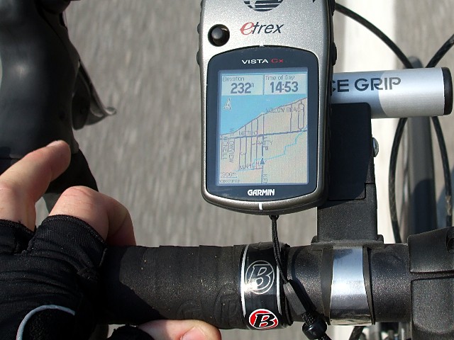
I’ve been looking for a bike GPS. Care to offer any words about the one pictured?
I’ve been eyeing that 12.20 train from Niagara Falls to Toronto. Google says it’s about 130 km one way, so I think if I got up early enough I could make that train and be home for afternoon tea.
The ride from (or to, I imagine) Niagara Falls is fun. If I was doing it again, I’d give myself more time to enjoy the sights along the way. In particular, I’d ride farther along the Welland Canal and take the little ferry at Port Robinson.
The Garmin Vista eTrex Cx is the second one I’ve had from the eTrex line, and I quite like it. I’ve been using it for about 2-1/2 years. The interface can take a bit of getting used to, but I think that’s common to all of these small units. It has way more features than I need for cycling (the Jumpmaster application, which tells you when to jump out of a plane in order to land on a specified target, is just one example), but the size is just about perfect for mounting on the handlebars and seeing where you’re going and where you’ve been, recording waypoints, and navigating.
My only real quibble would be that the auto-routing (where you feed in a destination and the unit picks an on-road route for you to follow from your current location) is somewhat hit and miss, especially if you set your vehicle type as a bike. As with Google Maps, it never met a highway that it didn’t like and doesn’t always know what to do if you tell it to stay away from them. I usually pre-define routes before my trip or don’t use routes at all, so this doesn’t really affect me. This feature may have been improved in more recent versions.
I might look at one of the small touchscreen units if I needed a new one today, though I don’t know how usable they’d be on a bike. I was checking out the cycling-specific Garmin Edge 605 and 705 GPS units just a couple of days ago, but they’re awfully expensive for what I consider to be marginal improvements and a couple of big drawbacks over the eTrex series.
You probably can’t go wrong with any Garmin or Magellan handheld GPS that supports maps. My personal bias is to avoid anything that doesn’t use AA batteries: the last thing I need is limited battery life and yet another charger to haul around with me.
Sounds like a great ride. I’m sure you can do 200. Do you ride with any groups at all? I never realized until this year how much easier it is.
I have the exact same GPS, and I really like it for times when I need it. It’s what helped me route my first 200k on the fly. The routing is pretty good, the AA batteries are VERY nice to have, and the barometric altimeter is MUCH more accurate if you save your tracks to review after your ride.
This year I stopped using the Vista CX for rides and I rely on my Edge 305 for recording/bike computer duties and my iPhone for routing, snapshots, and (when battery power permits) occasional live tracking. The iPhone I’d be bringing anyway, and the Edge is a much nicer fit on the bike.
I’d love to have the proper mapping features of the 705, but they ARE damn expensive for what you get. To me it wasn’t worth paying three times what my 305 cost so I can get colour and mapping, when my phone does both better. The 305 can be programmed with courses before you ride (similarly to the Vista’s tracks), which can act as a map, or at least tell you when you’re off course.
The heart rate recording of any of the Edge/Forerunner units has become invaluable to me, and I don’t think I would want to use a GPS without it. When my Forerunner broke I felt like I was missing out on a lot of data by using the Vista.
Val, are you using your GPS tracks to geocode your photos? The great thing about the newer versions of the Vista software is they keep better GPX logs saved on the memory card. I didn’t even know they were there until I plugged the card into my computer. 🙂
Rides longer than a couple of hours are almost exclusively solo. It’s not so much that I wouldn’t ride with a small group, but that my riding is erratic: I’m constantly doubling back, taking detours, and exploring all the interesting little places at the side of the road. I know that I’d find it pretty annoying riding with someone who was constantly stopping or going off course. I used to have a similar problem on group hikes. To get around it, I’d do the hike once with the group and then do it again solo immediately afterward so that I could spend an hour at a waterfall or exploring some random ruin that caught my eye without holding up a dozen other people.
I don’t geocode my photos yet, but it’s been on my list of routines to establish when I get a chance. I do save most of my GPS tracks.