
This past summer was a busy time in Dodgeville and, as always, there were far more pictures taken than posts about them. Here’s a gallery of just a few of the things that didn’t quite get into their own posts.
Random Wanderings and Wonderings
This past summer was a busy time in Dodgeville and, as always, there were far more pictures taken than posts about them. Here’s a gallery of just a few of the things that didn’t quite get into their own posts.
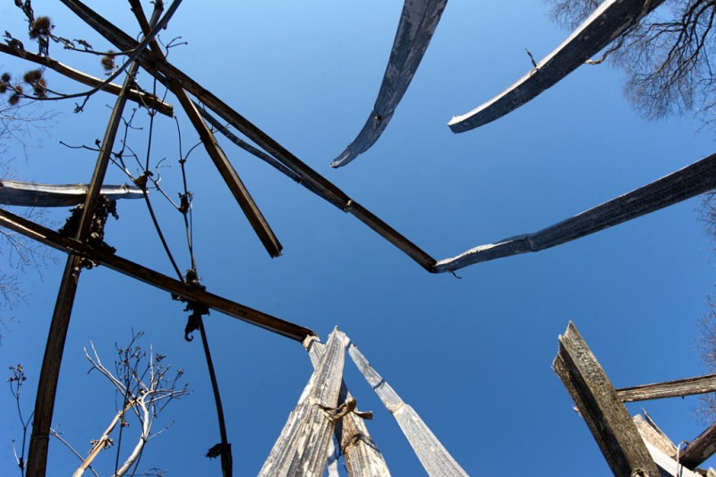
I mentioned Presqu’ile Provincial Park’s horse trees—Risa prefers the term “camel trees”—in my anniversary gallery post last week. They’re so-called because their swaybacked trunks resemble saddles and people (including Risa and me) love sitting on them for pictures. Trees like this aren’t unique to Presqu’ile, but what is unique is that there are several dozen of them concentrated in a small grove and are all presumed to have developed their distinctive form as a result of the same weather event about 120 years ago.
Ball’s Mill Conservation Area, north of Cobourg in the hamlet of Baltimore, has a few horse trees too and one of them is remarkable for having not only a saddle, but what appears to be a front limb and a very long neck too:
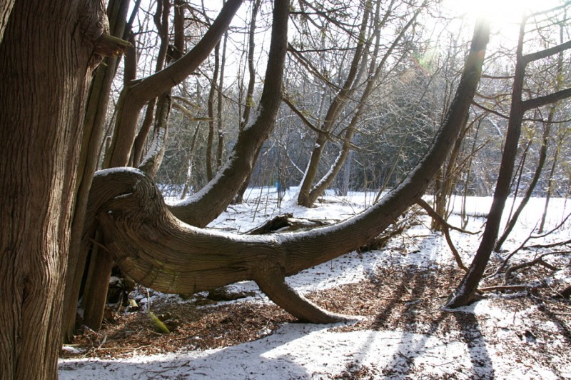
You can see a couple of additional views of this tree and the explanation of this kind of formation from the info board at Presqu’ile after the jump.
I published my first public post on this blog five years ago today. Writing a blog always struck me as kind of a funny thing to do, so I always wanted to have fun with it. My work largely requires me to fix problems (occasionally of my own creation) on relatively short timelines so I’m used to quickly identifying issues and researching solutions to the various technical absurdities and contradictions that I encounter. I suppose that mindset translates into my Dodgeville ramblings as well. In a lot of ways, updating Dodgeville is a release valve, a way to get something off my chest or to put aside some other problem for a few minutes while I slap together a post. Although I write primarily for my own enjoyment, I greatly appreciate that you, my loyal half-dozens of readers, accompany me on my journeys through the city, the countryside, and the boxes in my basement.
The topics I cover are frequently hyper-local and the posts often more detailed than necessary. Indeed, something as minor as repaving of a road around the corner from my house merited a grand total of six posts (so far) examining the results. A big empty field has been the subject of three recent posts. And on days when I’m too lazy to go outside, I just write about random things I pull out of boxes in the basement. I’ve sometimes thought about resubtitling Dodgeville from “Random wanderings and wonderings” to “Stuff within a five-minute walk of my house and sometimes not even that far.”
One of the eternally frustrating things about blogging is having too many things to cover and not nearly enough time to write about them all. So my digital archives slowly fill with clippings, links, pictures, snippets of potential posts, research reminders, and large projects that just haven’t come together yet. Some of those projects have been hanging around on my to-do list since 1994, waiting for technology to advance to the point that I’ll be able to do justice to my vision. One project idea that I had in 2006 will finally be coming to fruition this summer. Many others continue to bide their time, already born of my 1% inspiration and awaiting my 99% perspiration. Still other posts await because they were no longer timely when I finally got around to writing them, but will almost certainly be topical again at some point. Yet more ideas never made it into the serious consideration stage, including Bruise of the Week, Grave of the Month, and The Daily Sock. Consider yourselves lucky.
It’s been three years since I did one of these anniversary posts, so rather than going back and picking out my favourite posts since then, I’m going to put up a short gallery of a few interesting pictures that never made it into full posts for one reason or another. As always, thanks for reading, and I hope you accompany me for another year of wanderings, amusement, outrage, and signs. Always more signs.
Check out the random gallery below the fold.
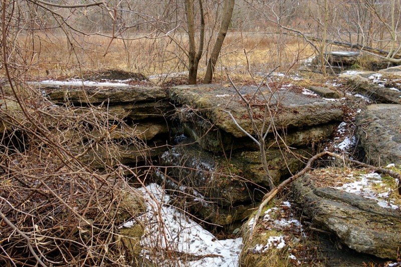
The strangest thing in Cottonwood Flats is what my fellow Don Valley explorer Rudy Limeback calls “Slab City.” That’s as good a name as any that I can think of, so I’m going to run with it. Slab City is a series of concrete and asphalt slabs piled about 5–7 feet high that runs along the bank of the Don River in Cottonwood Flats. A very short portion of Slab City is visible in this view from Bing Maps as the jumble of big square rocks near the middle of the frame. I don’t know anything about the origin of the slabs, or when or why they were placed along the river. I do know that their placement predates my first bike ride around the site sometime in the late 80s. They are all reinforced concrete and some have a layer of asphalt on top of them, so I’d speculate that they were part of a bridge deck at one point. The Leaside Bridge was rebuilt in the 1960s and is close enough that this site would have been a convenient dumping ground. That’s just conjecture, though. A more fanciful conjecture is that they’re the remnants of the Bayview Ghost. Note that I don’t actually believe this to be the case, but wouldn’t it be awesome if it was? Check out the short gallery of Slab City below the fold.
Cottonwood Flats [PDF] in the Don Valley is no stranger to industrial degradation. Before being used as a snow dump by the city, the site was home to a series of mills and factories beginning more than 200 years ago (here’s an interactive map of Cottonwood Flats, Crothers Woods, and adjacent areas). I remember tooling around the trails on my bike and navigating around the big sloppy pile of dirty ice and garbage that still towered overhead in the middle of the valley floor as late as June some years. Recognizing that it’s not really a good idea to use a site that drains directly into the Don River as a dumping ground, the city finally ended its use as a snow dump in 2009. It has since been renaturalizing and there is supposed to be a new management plan that I haven’t been able to find online.
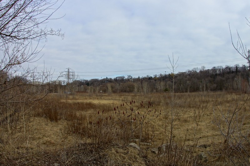
As you can see from the picture above, Cottonwood Flats in winter is very much a reflection of Toronto itself at this time of year: flat, barren, and relentlessly brown. With the DVP just across the way, the Bayview Extension at the top of the hill, and two railways nearby, there’s no mistaking this for a bit of pristine wilderness in the middle of nowhere. At first glance it seems like little more than an overgrown field beside a noisy highway, but the site’s edges, especially along the river, are filled with winding paths that carry you to a variety of interesting nooks and crannies. In the last few years, it’s also grown to be a much more popular destination for cyclists, families, and especially dog walkers. I’ve seen more people on my two recent visits this winter than I ever used to during the summer. Read below the fold for the first of two short galleries (or second of three, if you include the one from a couple of weeks ago) looking at a few of the interesting sights.
[This is a repost of an article that I originally put together for Torontoist in 2008. Torontoist’s recent redesign seems to have eaten all of the photo galleries in older posts, so I’m adding this one here because it was way too much fun (and work!) to allow it to disappear into the ether.]
Mr. Stickman has the toughest job in Toronto: keeping you safe. In a day’s work, he gets smushed, crushed, beheaded, befingered, mangled, strangled, thrown, blown, ground, and crowned. And unlike the relatively delicate spokesmodels who calmly remind you to mind the gap or use proper escalator technique, Mr. Stickman is willing to give the extra effort and actually demonstrate the consequences of not following the rules. Wherever danger lurks, Mr. Stickman plies his educational trade. He endures every manner of indignity, accident, and disfigurement that you can imagine, all in the hope that you will learn from his painful and sometimes deadly misadventures. What follows is a small sampling of his daily work around Toronto.
I set myself a challenge when Risa and I took a walk through the wildflower preserve at Todmorden Mills this weekend: to use a single fixed focal-length lens (16mm fisheye in this case) for the entire outing. Something about it seems old-fashioned: in an age when super zoom lenses can be found on virtually every camera, you might as well be wearing pants up to your armpits, wagging your finger and starting every sentence with, “Back in my day…” Still, it’s a good exercise to learn to zoom with your feet again. It gives both you and your pictures perspective.
This being January in Toronto, there just aren’t a lot of wildflowers around. There’s also not much more than a smattering of snow and ice here and there, making everything at ground level relentlessly brown. Even so, the preserve was fairly busy when we went, with a number of families and dog walkers enjoying the short trail, sunny skies, and relatively balmy weather. We were each armed with a camera but seemed to be the only ones taking pictures.
Check out the short gallery below the fold.
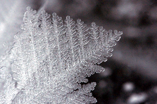
Seeing a large ice crystal like this, about an inch long, is fairly rare. Now imagine seeing thousands upon thousands of them:
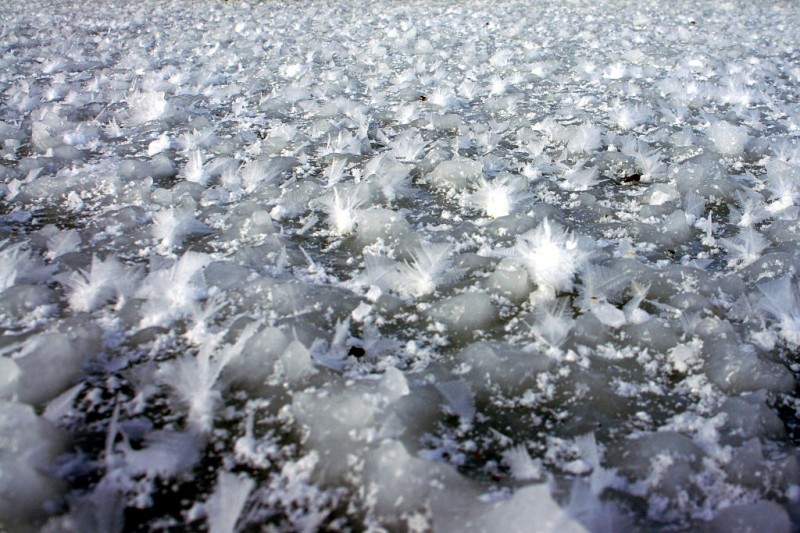
We’re spending a few post-Christmas days at the cottage and awoke to a visual treat on Thursday: Wednesday’s sudden deep freeze and blowing wind gave us a large field of feather ice growing on the lake. The lake began the day on Monday as completely open water; Tuesday brought some long ribbons of ice along the wind lines; by Wednesday only a few open spots were left, and by Thursday morning it was completely frozen over. I don’t know much about the formation of feather ice, but I’m guessing that the low temperatures combined with the wind blowing over the remaining patches of open water on Wednesday picked up enough moisture to cause this field to form near our shoreline. It’s at least a hectare in size.
I would have spent much more time taking pictures, but lying down on a frozen lake while manipulating an SLR on a tripod at ground level isn’t exactly the most comfortable position I’ve ever been in. Check out the gallery below the fold for a couple of additional pictures I managed to take before my pants froze to the lake.
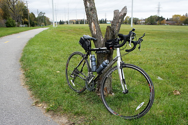
I’ve really been looking forward to the completion of the trail through the Gatineau hydro corridor that bisects Scarborough. It was supposed to be finished in March of this year, and then in September, but work is still ongoing. All of the paving is done, but traffic signals, benches, and other finishing touches are still going in. I didn’t want to wait until the spring to ride it, so I took a couple of rides last week to check it out.
Overall, I’d say that the path is a huge improvement for cyclists who want a through-route across most of Scarborough. There are still some rough spots along the way and gaps in the route, particularly between Ellesmere Road and the 401, but riding the disjointed route is still preferable to my old routes to get to the northeastern corner of Scarborough and beyond, which involved long stretches of misery fighting with traffic along McCowan, Warden, Sheppard, Steeles, or any of the other arterials where there’s little choice but to put your head down, grit your teeth, and pedal as fast as possible.
The Gatineau corridor trail is comprised of several new or upgraded sections of path that join a smattering of Metro-era paths into a nearly continuous off-road route from Victoria Park Avenue just north of Eglinton Avenue clear across Scarborough to Meadowvale Road north of Sheppard.
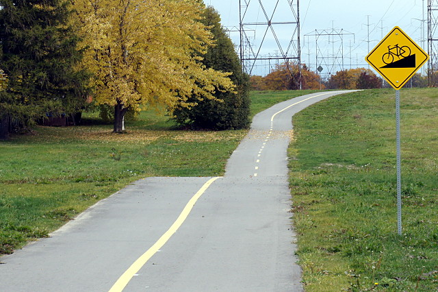
The route tends to meander a bit and goes on-road in two places, sometimes quite a distance away from the hydro corridor before joining up again. The wayfinding is adequate and always shows the next street or two, but doesn’t include major destinations, area maps, or links to other trails. Sometimes you get dumped at a crossing with conflicting signage or no signage at all.
The city’s original project presentations [PDF] for this route recommended an on-street connection along Ellesmere from where the trail currently ends at the western end of Miliary Trail to Conlins Road, where you pick up the trail again after crossing the 401. Instead, I would recommend turning left up Military Trail at Ellesmere, and following Military Trail to…Ellesmere. It adds about a kilometre to the trip, but it saves a truly miserable ride along Ellesmere. In addition to high-speed traffic and relatively narrow lanes, the map doesn’t show that on Ellesmere, you have to climb two big hills out of the Highland Creek valley. If you follow Military Trail instead, you avoid the second valley and only have to deal with one climb. There’s also less traffic and a fake bike lane along a significant portion of the road.
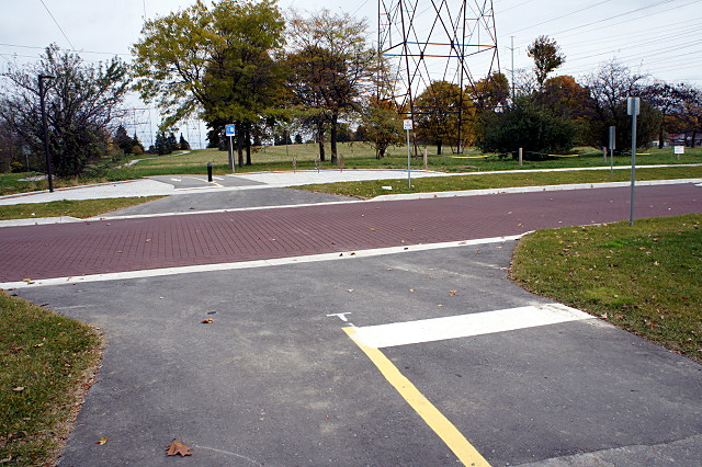
Bike and pedestrian signals have been added to all major road crossings, though not all of them have been activated yet. Even when the trail coincides with a major intersection (as at Lawrence and Brimley), cyclists are given their own crossing signals and path adjacent to the pedestrian crossover. At minor streets, cyclists generally face a yield sign and, remarkably for Toronto, are not told to dismount to cross. There are a couple of exceptions, but they both seem to be leftovers from the Metro era trails.
For future work, I’d really like to see the two most significant gaps filled in: from Military Trail to Conlins, and from Victoria Park to the Don Valley. Add infrastructure to those two sections and you’ve got a near-continuous off-road path from downtown to the farthest reaches of Scarborough.
On its way to the Ontario-Quebec boundary, this corridor passes just a few kilometres away from my cottage. So, when can I get the rest of it paved?
The gallery below has a partial tour and some specific commentary about aspects of the trail that I like or that could be improved. Traffic lights and paint will be in place eventually, so I’m not terribly worried about that. I’m looking forward to escaping the city more often via this path.