I just saw an interesting WWF-Canada commercial on TV. The spot is a series of vignettes of activities that have been considered normal at some point in the past: unrestrained kids jumping around and playing in a convertible moving down the highway, a doctor lighting a cigarette for a pregnant woman, a man patting his secretary’s behind after she brings a drink to his desk, and so on. It ends with the message, “The world has changed,” and a shot of a man in a suit carrying his bicycle out of his townhouse and starting his ride to work. “You can too.”Brilliant. This is exactly the kind of message needed to counter the head-in-the-sand viewpoints of people like Case “people won’t get out of their cars” Ootes and Roger “if you’ve got $1.8 million to spend I think you can find something better to spend it on than bike racks” Anderson. A few of us already think that those two should be on display at the ROM.The TV spot goes with a print campaign that echoes the “society has changed” idea and features the tagline, “Not long from now, the way we’ve been treating the planet will seem just as wrong.” We can only hope.
Category: changes
Old Don Mills Road
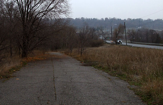
Most people wouldn’t associate Toronto with abandoned roads, but a few of them dot the city if you know where to look. One of the better examples is this surviving portion of old Don Mills Road as it climbs north out of the Don Valley. The current Don Mills Road is to the right in the picture above. The original road was realigned and widened in the 1950s to connect the new community of Don Mills to the north with the established community of East York to the south.
The old road was mostly eliminated south of Overlea Boulevard, but a short section about 200 metres long survives more or less intact, just out of view of the thousands of drivers hurrying past. It’s currently used by bicycle commuters and local residents as a shortcut into the Don Valley trail system. The trees and weeds encroach on the road a little bit more every year.
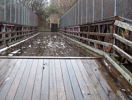 Directly south of here is the single-lane Bailey bridge that carried the road over the CN tracks for a time before being replaced by the modern overpass a few steps to the west. The bridge is still in use as part of the main pedestrian and cyclist route through the Don Valley. If you look closely, you can still make out the name of the manufacturer—England’s Appleby-Frodingham Steel Company—on some of the beams.
Continue south across the Bailey bridge and down the hill and you’ll come to another bridge that was part of the original road. Visible from the DVP near the Elevated Wetlands, the old concrete bridge still carries vehicular traffic over the East Don River to a small parking lot.
To find old Don Mills Road, walk south on the east side of Don Mills Road from Overlea Boulevard. After the sidewalk ends, follow the narrow dirt path until it curves to the left and takes you to the old roadway. From the south, walk up the stairs from the main park pathway at the northern end of the Bailey bridge.
A version of this article originally appeared on Torontoist.
No future in petroleum, 1857 edition
I’m a little behind on my reading, but I couldn’t resist sharing this nugget of prognostication from the May 1857 issue of Scientific American:
We believe that no particular use is made of the fluid petroleum, from the ‘tar springs’ of California, except as a lotion for bruises and rheumatic affections. It has a pungent odor, and although it can be made to burn with a pretty good light, its smell is offensive. This, perhaps, may be obviated by distilling it with some acid; we believe that this is not impossible in this age of advanced chemistry. If the offensive odor could be removed, a valuable and profitable business might be carried on in manufacturing burning fluid from it.
This quote was published earlier this year in Scientific American‘s monthly “50, 100 & 150 Years Ago” feature, where they reprint snippets of interesting stories from back issues of “the oldest continuously published magazine in the U.S.” Pungent, offensive, and the basis of the modern world. Seems about right.
Memories of the monorail
For people of a certain age, memories of the Toronto Zoo begin with riding the old monorail. Only it wasn’t the old monorail back then—it was the super-futuristic monorail. The line was abandoned following a 1994 accident that injured about 30 people, and the train’s power supply rails and portions of the guideway were removed a few years later. But if you know where to look, most of the route remains visible as it snakes through the grounds of the zoo.
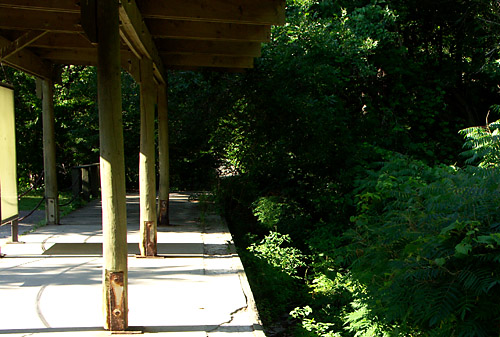
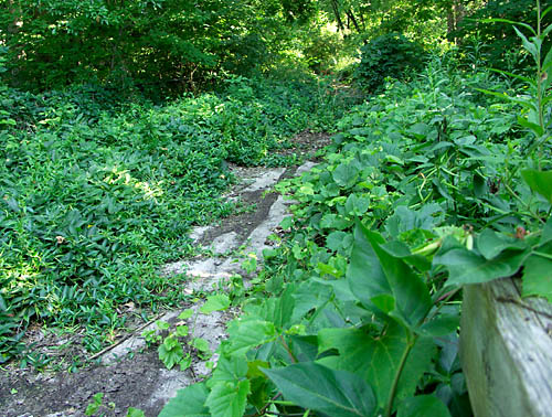
The abandoned station above is in the Canadian Domain, midway between the grizzlies and the enormous bison enclosure. The guideway remains intact under all that foliage at the edge of the platform even though the vegetation gains ground every year. Other sections are still in pristine condition, almost as if the next train is only minutes away. Watching the monorail be consumed by nature is a small preview of what the world would be like without us.
Take a Google Maps tour of the monorail starting here. The train ran on the track in the center of the map curving down to the right. You can trace the remnants of the route three-quarters of the way around the zoo before it finally peters out, passing by two abandoned but still-standing stations along the way. A third remains in service near the main entrance, used for the monorail’s rather pedestrian replacement, the Zoomobile.
The really surprising thing about following the train’s route in Google Maps is just how much of it goes through what are still completely undeveloped parts of the zoo in the southern portion of the grounds. It’s easy to forget just how enormous the zoo is—at 710 acres, it’s seven times the size of the San Diego Zoo. The monorail used to be the only way to see to the bison, which are kept in an enclosure that itself is probably larger than many zoos.
In addition to visiting the Canadian Domain station in person, you can catch a glimpse of the other lost station if you take the Zoomobile ride: look down and to the right as you cross over a bridge after the Americas Zoomobile stop. Pay attention transit fans, this is what the Sheppard subway could look like after sitting unused for a few years.
Oh, and of course, an abandoned monorail isn’t the only thing to see at the zoo; the animals are worth a trip too.
A version of this article appeared on Torontoist.
Cyclist's revenge redux
I wrote about my encounter with a delivery truck driver in an earlier post. With the two of us living and working in the same neighbourhood, it was inevitable that our paths would cross again. That came on Saturday, a scant three days after our first encounter.
This time, we were headed in opposite directions on Danforth. He was turning his van left at an advanced green. I was in my customary position at a red light, straddling my bike in the centre of the curb lane. Indeed, it’s the very stance I’d maintained during our first meeting.
In stark contrast to Wednesday’s shouts and frustration, we exchanged only smiles and friendly waves on Saturday before heading our separate ways. Surely this shared gesture counts as a small victory in the battle to get motorists and cyclists to respect one another. Maybe we can all just get along after all.
The right to roam
A member of one of my mailing lists recently posted a link to a story at the Daily Mail called How children lost the right to roam in four generations. It looks at four generations of a family in Sheffield and examined how far from home children of each generation were able to wander from home unaccompanied. The great-grandfather was allowed to walk six miles to the local fishing hole at the age of eight, while his eight year old great-grandson is now only allowed to roam within a 300-yard radius.
The gradual erosion of kids’ freedom is so universally accepted that it’s not really news. But what makes the Daily Mail article so compelling is the graphic that accompanies the story: it overlays a map with the roaming area of the four eight-year-olds, showing how dramatically children’s worlds have been shrinking.
With that in mind, I’ve taken a Google map satellite image of my old neighbourhood in East York and overlaid my own roaming area as an eight-year-old in the late ’70s. The result is the graphic below.
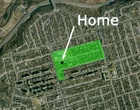
The farthest from my home that I was allowed to venture alone was a little over 500 metres. But within that 500 metres were two playgrounds, a school yard, a swimming pool, a wading pool, a library, numerous stores, a restaurant, a haunted house (or so we imagined), and most of my friends.
Venturing farther afield or crossing any of the local main streets required being accompanied by an older friend or family member. We moved to Scarborough the next year, where my authorized roaming radius increased to well over a kilometre; my unauthorized radius, previewing the explorer I would eventually become, was larger still. When we moved back to East York three years after that, my catchment area expanded to virtually anywhere the TTC, my bike, and my twelve-year-old feet could take me.
How far were you allowed to wander as an eight-year-old?