Lost Passmore Avenue

 Passmore Avenue looking west, west of Beare Road
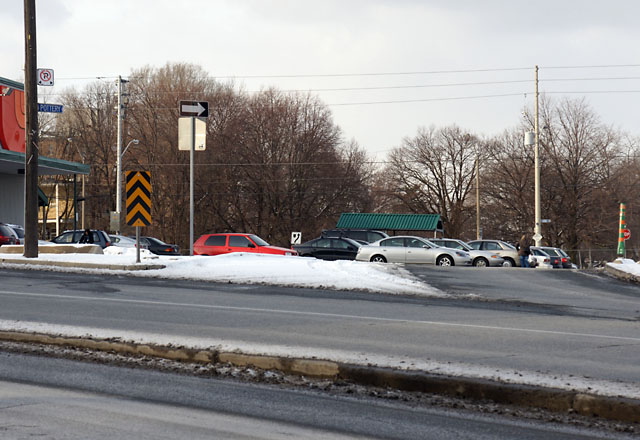
Passmore Avenue looking west from west of Beare Road.

If you’re familiar with Passmore Avenue in Scarborough at all, it’s probably as an unremarkable industrial street that runs in two discontinuous sections between Kennedy Road and Markham Road. But along with the rest of the concession roads in Scarborough, it long predates suburbia: it was laid out and cleared in the 1800s. On an 1878 map, Passmore (then known only as Concession Road 5) stretched 14 km clear across the township of Scarborough with only three short sections missing where the road would have crossed the Rouge River. More modern maps and aerial photos show that Passmore remained a country road crossing Scarborough well into the 1960s, when portions of it started falling to suburban development or neglect.

Although the Passmore name has virtually disappeared over the last 50 years as Scarborough grew from farming township into a suburb, most of the original route still carves its way through the former borough. West of Markham Road, the original road allowance is given over to portions of more than a dozen different suburban roads and park pathways that trace the old road, starting with Gordon Baker Road in the west and continuing to Ketchum Place near Middlefield Road. Drivers can’t follow the entire road thanks to all of the twisty-weavy suburban streets, but multi-use paths directly connect the whole route (except for one block) to allow a continuous 8 km long suburban walking or cycling tour along the old right of way from Victoria Park Avenue to beyond Markham Road. There’s no physical evidence of the original road here other than the straight route through the heart of suburbia.

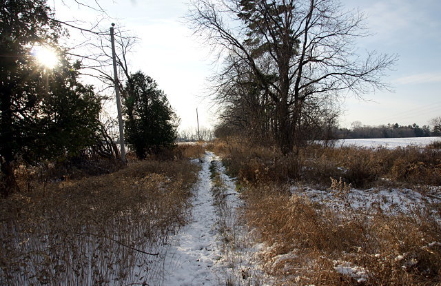
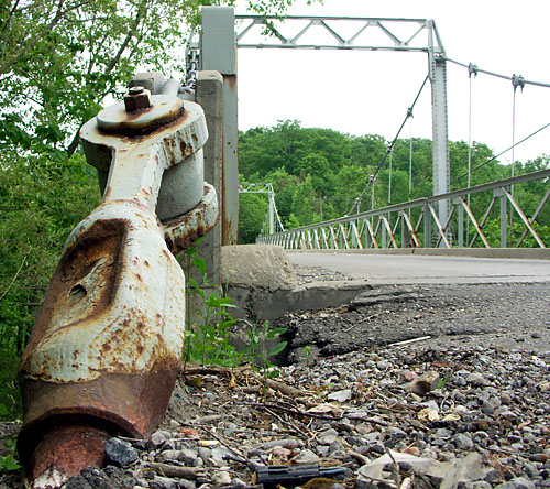
East of Markham Road, Passmore was never much more than a dirt road through the countryside. Except for three very short half-blocks that still exist, most of it no longer appears on maps and has dropped off the municipal street grid. Yet the old road allowance remains largely open to intrepid hikers in this rural corner of the city. The most accessible portion of Passmore Avenue runs between Gordon Murison Lane and Beare Road, where a line of utility poles stands guard over the old dirt road as it dips into a small valley, passes farm fields on either side, and crosses a small tributary of the Rouge River before climbing back up a low hill at the other end.

A partial tour of the eastern half of Passmore and more photos are below the fold.

Read More …

Goin' down the road

Goin’ down the road

It feels like months since I’ve gotten out for a good ride but I was finally able to hit the (dirt) road yesterday, heading out into the farthest reaches of Scarborough. With the country roads, fields of corn, tangled meadows, and overgrown forests, you’d never know that you were still inside Toronto on the municipal street grid. But then you pass one of the familiar bike route signs (seen here at the rural intersection of Beare Road and the wonderfully-named Plug Hat Road) and you know that you’re still within reach of civilization:

Bikeway network signs at Beare and Plug Hat

This isolated corner of the city is plagued by illegal dumpers and it shows in the informal signage along the roads:

Informal signage on Reesor Road

In the last couple of years, northeastern Scarborough and neighbouring northern Pickering has become one of my favourite cycling destinations. The best thing about riding there (or almost anywhere) at this time of year and in cool, rainy weather is that you basically have trails and roads to yourself.

Pottery Road: The original Toronto Bypass

Somewhat related to my previous post, Pottery Road has a little-known connection to another Toronto street: Davenport Road. The East York Library monograph Fascinating Facts About East York (and some of them really are, at least to east-end geeks like me) says that Pottery Road:

may have been a part of an old Indian trail that crossed the city along what is now Davenport Road and entered the Don Valley through the Rosedale Valley ravine. There are records of the Mississauga Indians having encamped on the Don near Pottery Road as late as 1831.

I always find it interesting that so much of our modern infrastructure follows old trails, watercourses, and terrain, even decades or centuries after after the old features have ceased to exist on any meaningful level. Technology may have brought us huge bridges across the valley and personal motorized transportation, yet there’s Pottery Road, tracing an old footpath in the Don and still used by thousands of people a day. Some things never change.

Old Pottery Road walking tour

Pottery Road

Frequent northbound travellers on the Bayview Extension have probably noticed the “Pottery Road” street sign pointing to a glorified supermarket driveway at the top of the hill, just south of Moore Avenue. Some may even have wondered how it relates to the more familiar street of the same name almost 1.5 kilometers to the south, winding up the valley wall to Broadview Avenue. The answer to this puzzle is that the two Pottery Roads used to be one, connecting Broadview and Moore Avenues, roughly following Cudmore Creek for much of its length.

Most of the road was abandoned when the Bayview Extension was constructed in the late 1950s. The section running from Broadview to Bayview was left mostly intact (and the top of it was later realigned to allow an easier climb out of the valley), as was a very short block at the northern end of the road, now flanked by parking lots for a supermarket and a bank.

What about the kilometer of the road that used to connect the two remaining sections? Unlike most abandoned roads that exist only for short stretches of their former selves, old Pottery Road is unique: its entire original route from Broadview to Moore is still open and can be hiked from beginning to end. Read on for the complete walking tour.

Read More …

Life out of balance

(I liked the headline from my recent Torontoist post on the same subject that I’m reusing it.)

Rock towers in the Humber River
Peter Riedel could hardly have chosen a better location to ply his trade. I’ve seen rock balancers in the eastern beaches, in the western beaches, and even at the Ex, but this is the first time I’ve seen one working the Humber River. Literally in the river.

The artist and some of his creationsThe Humber cascades over a low waterfall in Étienne Brûlé Park before bubbling just a few centimetres deep across a short stretch of river rock. The only sounds here come from the rushing river and picnicking families. Visitors to the park on a busy Sunday afternoon include cyclists, walkers, joggers, and skaters. And then there’s the guy crouched in the middle of the river with a rock in his hands, surrounded by some 50 rock towers of every imaginable description.

Riedel, who has been balancing rocks on the Sunnyside Beach seawall for three seasons, recently moved up the Humber to take advantage of the idyllic setting, the abundant raw material, and the permanence the river lends to his work. He found Sunnyside less than ideal with the constant din of nearby traffic on Lake Shore and the Gardiner breaking his concentration and the constant danger that his towers would be toppled by careless passersby and malcontents. In contrast, it’s hard to imagine anyone accidentally bumping into a rock tower in the middle of a river.

The phallic sectionDaryl Maddeaux, who builds impressive towers at the Ex and other special events, once answered a query from the crowd by saying that rock balancing is more about patience than skill, and that anyone could do it. Since then, I’ve always wanted to try my hand at it. Unfortunately, I’m fairly certain that I don’t have the patience. For the moment, I’ll settle for the home version I received as a gift last year.

50 perfectly-balanced towers in the river

More than 50 towers dotted the river by the time Peter was done that day.

The view from afar

From afar and backlit, the towers look like people standing in the river. Only one of them in the picture above actually is a person.

There’s no trickery involved in rock balancing, just patience, skill, and artistry. Maddeaux always makes a point of knocking down his towers at the Ex by lobbing little pebbles at them, to demonstrate that the towers are held together by nothing but gravity and even the slightest shift will topple them. Life, out of balance.

A version of this article originally appeared on Torontoist.

Toronto's only suspension bridge

Sewells Road suspension bridge in Scarborough

Tucked into the northeast corner of Scarborough near the Zoo, Toronto’s only vehicle-carrying suspension bridge straddles the Rouge River. A small handful of other suspension bridges dot the city, but carry only pedestrians and cyclists. Transportation Services was taken by surprise upon my first inquiry and couldn’t immediately confirm that this was a true suspension bridge. But John Bryson, Structures and Expressways Manager for the city, verified that it is indeed a “suspension bridge with the side trusses as stabilizers for the deck.”

Sewells Road suspension bridge in Scarborough

Built in 1912 and one of fewer than 15 bridges listed in Toronto’s inventory of heritage properties, the bridge can be seen by traveling through the Scarborough countryside on Sewells Road north from Old Finch or south from Steeles. Transportation Services also told me that the bridge is due for rehabilitation in the near future and that it may need to be altered from its current form. Best get thee to Scarborough to see it before the bean counters and Leon’s get their mitts on it.

The local scenery in this corner of the city will make you forget that you’re still in Toronto. Unfortunately, the illegally-dumped trash and auto wrecker up the street will remind you that you’re still in Scarborough.

Sewells Road suspension bridge in Scarborough

A version of this article originally appeared on Torontoist.