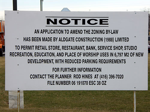
The zoning application for 2050 Ellesmere Road in Scarborough covers all the possibilities except, strangely enough, condos.
Random Wanderings and Wonderings
The zoning application for 2050 Ellesmere Road in Scarborough covers all the possibilities except, strangely enough, condos.
There seems to be a lot of angst and disappointment in the cycling community regarding the West Toronto Railpath. In particular, some cyclists are upset that this new multi-use trail isn’t a dedicated bicycle highway heading downtown. The disappointment is especially evident in a post titled This is not a bike path at the Spacing Wire and the comments that follow it.
Some cyclists seem to have built this route up in their mind so much that anything less than a DVP for bikes leading straight into the train sheds at Union Station would have disappointed.
The main issues with the Railpath seem to be:
Let’s look at these issues one at a time:
It’s too short. Well, yes. All parks and paths are. I wish the Don Valley trail system ran uninterrupted all the way up to the headwaters on the Oak Ridges Moraine.
The complaint here is that the northern section of the trail, the only part being built right now, doesn’t really “go” anywhere and thus isn’t usable as a commuting route. And that’s fair. But as the first phase in what we all hope is a 2- or 3-phase project that eventually lengthens the park when the city gains control of the southern sections, it’s a good start. No one would be happy if we simply sat on the barren corridor until the entire thing could be built, either. We have to start somewhere. The “all or nothing” approach advocated by some is unreasonable here.
It’s not a bicycle expressway. Again true, and this ties into the previous issue. But I think a lot of cyclists have been taking this expression a little too literally. There is no dedicated bike expressway in Toronto. There never has been. And there never will be, unless the city is taken over by rabid cyclists who implement Velo-city. Yet there are plenty of routes that offer speedy and/or scenic commutes.
The Railpath is, first and foremost, a park that serves its community. Expressways, whether for car or bike, divide neighbourhoods. They discourage visits to a neighbourhood and instead encourage speedy travel through them. While this may be desirable to the commuters, it is undesirable to the neighbourhood. I would certainly agree that a highway for bikes is less invasive than one for cars, but it still wouldn’t properly serve the neighbourhood that it slices through.
It’s not dedicated to cyclists. It simply doesn’t make any sense to build infrastructure solely for cyclists at the expense of other non-motor-vehicle users. The best you’ll ever get is a multi-use path. Even in parks where parallel trails exist, one is signed pedestrian-only and the other is signed multi-use for pedestrians, cyclists, bladers, and whoever else wants to use it. Cyclists will always have to share the trails with other users, and that’s the way it should be. Cyclists and pedestrians shouldn’t be adversaries. If your sole goal is to ride as fast as possible from A to B, stay on the road. And lobby your politicians for more on-road bike lanes.
The pathway is too narrow. Actually, it seems to follow the same specifications as other mixed-use paths in Toronto, including ones that are used as de facto “bike expressways” like the Lower Don and Martin Goodman Trails. I cycle the narrow Lower Don pathway frequently and rate it as far worse than the Railpath ever could be. The main problem along most of the Don south of Riverdale Park is that the park is not much wider than the pathway. If you’re not on the path, you’re in the river or scraping your face along a chain link fence.
Much of the Martin Goodman Trail and virtually the entire Don park system feature similarly narrow trails, although the parks themselves are usually wider. Yet the kind of conflicts between users that cyclists are imagining will take place on the Railpath are virtually non-existent, particularly during typical commuting hours. Yes, it would be nice to have wider or parallel pathways, but what impact would that have on the park as a whole? At just 10-15 metres wide, there isn’t a lot of room in the corridor.
It lacks links to surrounding streets. This is a valid point. The worst thing about riding the Lower Don is trying to get out anywhere other than at the very bottom or top of the trail. Leaving the trail at Riverdale Park or Queen Street means having to haul your bike up a long flight of stairs. Those bike gutters beside the steps don’t help much and most people can’t quite figure them out. I find it faster and easier to just put my bike over my shoulder and sprint up the stairs, but I’m not an occasional cyclist out for a leisurely Sunday ride.
Unfortunately, they’re proposing this same kind of stairs + gutter configuration for access to the Railpath from Bloor and Dupont. It’ll probably discourage use of the Railpath by some cyclists.
As for connections to other cycling routes, the Belt Line is similarly isolated, directly connecting only to a scary-to-the-novice pathway in the Moore Park Ravine to the south. In the north, it’s a few blocks away from the Cedarvale Ravine system. It crosses a smattering of signed routes along its length, but no streets with dedicated bike lanes. Yet the lack of direct connections to the Belt Line doesn’t prevent it from being an immensely popular and beautiful ride.
The city probably won’t plough the route. Yes, welcome to the reality of off-road routes in Toronto. I’m not aware of any mixed-use path that receives city attention in the winter. There’s no reason that the Railpath would receive winter maintenance that no other trail in Toronto does.
That said, I think the Railpath should be ploughed in the winter. As should all of the other paved mixed use paths commonly used for bicycle commuting. But the city can’t afford it, you say? Nonsense. Since it’s already the responsibility of landowners to clear the walks in front of their homes and businesses, I’d like to see the city stop its sidewalk clearing service and instead dedicate its sidewalk ploughs to clearing park pathways instead. It would even end up saving money, as there aren’t nearly as many park pathways to clear as there are sidewalks. The city could continue to shovel for seniors and the disabled.
Although some parks are used in the winter by cross-country skiers and snowshoers (of which I’m one), they should still be able to ski or shoe beside the cleared paths. Dog walkers, cyclists, and nature lovers would rejoice.
I’d lobby my out-of-touch city councillor in this direction, but I highly doubt that he would take any cycling issue seriously.
No, I’m not talking about the kind of inspiration you get from Successories.
A post on the Spacing Wire last week pointed to a short film called Drum 13 (requires QuickTime 7) by Tony Round. The description read, “a banjo and a massive abandoned Cherry Beach oil drum really do belong together.” Drum 13 was filmed in February 2005. It turns out that in April 2006, I had visited the same location and taken these pictures, among many others, of that oil tank:
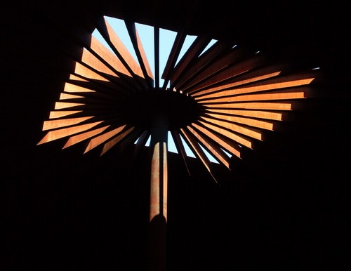
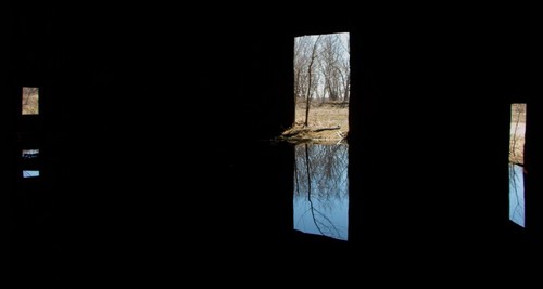
While I was there, I was struck by how this big old boring piece of industrial detritus could be so compelling a subject and offer so many interesting studies in light and form. I’ve always enjoyed taking pictures of industrial ruins, but this place was special. I couldn’t believe that I’d ridden my bike past it for so many years without once venturing onto the site and vowed to come back as the seasons changed throughout the year.
But by June 2006, the site had been leveled, and you never would have known that the empty field had ever held anything more substantial. It is currently being developed into the transitional sports fields in the port lands. The experience underscored the importance of timing: if you have a chance to take a picture, take it — the scene may not exist an hour from now, never mind next week or next month.
I lamented the loss of the picturesque location, but didn’t know that anyone else had appreciated its interesting features before I saw Drum 13 posted online last week. I wondered if anyone else had been artistically inspired by this storage tank. Some quick Googling found that at least a few other photographers and some musical experimenters have documented the location over the years. It’s good to know that I wasn’t the only fan of this abandoned piece of the city.
There seems to be a rather ambitious beaver at work in the Don Valley.
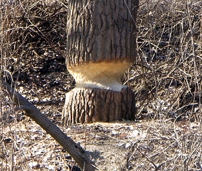
He still has some work to do before toppling this 30-footer at the forks of the Don, but he’s getting there.
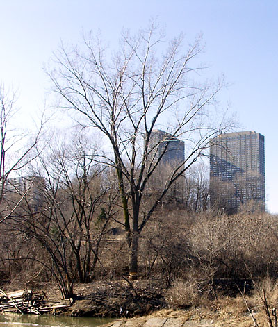
I’m reminded of the fossilized giant beaver tooth found at the Brickworks. Whether this modern beaver eventually succeeds or not, I’m pretty sure this tree has seen its last leaf. I wonder if Parks and the TRCA would allow a beaver to dam up the West Don at the forks. Probably not, but it would be something to see.
(The tree is visible from the park bridge that runs under Don Mills Road near the entrance to Taylor Creek Park. From anywhere on the bridge, look across the river toward the forks. You could also approach the tree directly from the eastern end of the Crothers’ Woods trail in the Flats.)
The Toronto Police issued a press release (thanks to Martino for the link) on Sunday announcing the start of Operation Safe Journey, a week-long blitz against drivers and cyclists who endanger pedestrians. Bravo! But tellingly, the press release also promises to target “pedestrians who fail to obey traffic signals or who fail to yield to traffic.”
If you believe the CityNews take on the crackdown, it’s aimed almost entirely at pedestrians. City’s story typifies the blame-the-victim mentality of the media and the police, stating, “Many of those killed last year were guilty of crossing the street in the worst possible place and at the worst possible time.” Mmm, smells like Rob Ford. Yes, it’s your own damn fault if you venture into the city without a car. You’ve got some nerve, not waiting (and waiting, and waiting…) your turn to cross the street. Don’t you know that streets are for cars?
So as a public service to the Toronto Police, I’m rewriting their press release. This is how it should read:
In 2006, there were 57 traffic fatalities in the City of Toronto. Thirty were pedestrians, with one?third of them over 65. In contrast, 38 people were killed by guns in the City of Toronto in the same period.
These were tragedies that need not have occurred.
As members of our society and as road users, whether as pedestrians, cyclists, or motorists, we share a responsibility for preventing these tragedies.
Motorists must exercise more caution when manoeuvring their 2-tonne vehicles around the city, and remember that pedestrians don’t have crumple zones, air bags, or seat belts to keep them safe in collisions. In fact, in your haste to be the last car turning through the advanced green a full 5 seconds after it stopped flashing, or make that right turn without looking where you’re going, or zip past the bus stopped in front of the crosswalk, you’re putting pedestrians’ lives at risk. Oh, and your premiums may go up a little after your insurance company pays a few thousand dollars to scrape a dead pedestrian out of your grill.
Being in a car does not automatically give you the right of way. Shaving a few seconds off your mad cross-town dash isn’t a good enough reason to endanger someone’s life. Just because a pedestrian isn’t in a car doesn’t mean that she isn’t in as much of a rush as you are to get to where she’s going.
Pedestrians should remember that many motorists don’t see you unless you’re inside a shiny metal box on four wheels. Many of those that do see you consider you to be a nuisance, serving no purpose but to delay them on their appointed rounds. The motorists who do treat you with the respect you deserve risk being rear-ended by all of the other motorists. Please look both ways before you cross the street.
On Monday, March 19, 2007, the Toronto Police Service will embark on a one?week education and enforcement campaign entitled “Operation Safe Journey”. This campaign will target motorists whose aggressive driving habits endanger the safety of pedestrians.
And next week, we’ll be running Operation Safe Shootings, a blitz targetting people who get shot. It’s their own fault, you know.
Of course, what they really wanted to write probably looks something more like this:
Hey Pedestrians! Get outta the way!
Note for the argumentative: I am a motorist, cyclist, and pedestrian, though not necessarily in that order. Of the three groups, motorists have the largest burden to act responsibly because of the amount of damage they can inflict on the other two groups when something goes wrong. Yes, there are irresponsible cyclists, and irresponsible pedestrians, but let’s be honest about where the responsibility lies.
“Nope.”
— The acting store manager in the Loblaws at Broadview and Danforth on Sunday, when I asked if he could do anything about the lineup that snaked from the one open non-express checkout all the way across the front of the store and up the dairy aisle.
“I keep forgetting not to come here anymore.”
— A frustrated woman making her way to the end of the line.
You and me both, sister. The newly-renovated Sobeys up the street beckons.
The TTC released its Transit City plan yesterday, to a predictable mix of hope and FUD (video) from the usual suspects. I freely admit that I’m no TTC expert, nor am I artistically inclined enough to offer alternative fantasy maps. Even most of my comments on the specifics of this plan would simply echo what’s available elsewhere, so I won’t add my voice to the cacophony. But I do have some preliminary thoughts on Transit City.
First, despite the upcoming hysterics of the naysayers — which will no doubt include my own city councillor and notable small-thinker Case Ootes — this plan is easily achievable if accompanied by some political will. Keen transit advocates are right that subways are just not practical or affordable for blanketing the city with transit and that LRT is the way to go. Will this network be expensive? Yes. But unlike the expense of, say, the Sheppard subway or the Spadina subway extension to Vaughan Corporate Centre, it will also be extensive.
Money and political issues aside, the two biggest threats to the success of this plan are internal: the city’s transportation department and the TTC itself. The TTC has become notorious in recent years for managing service quite poorly. In particular, they seem to focus too much on easily-graphed and ineffective internal performance targets rather than real-world performance from the customer’s perspective. This singlemindedness absolutely must change.
As for the transportation department, they have to be forced to give the TTC true signal priority along all of these routes. No ifs, ands, or buts. No half-baked priority like they’ve implemented down Spadina. Cars should always stop for an LRT; an LRT should never stop for cars.
Simply put, the city’s directive to the traffic managers should be that a TTC vehicle on a dedicated ROW should only need to stop when picking up or dropping off passengers. If an LRT vehicle is approaching an intersection, the lights should change in its favour, even if that means cutting short the cycle for intersecting traffic. Even if it means preventing cars from turning left until the LRT has passed. Even if it means stranding pedestrians at a traffic island. To be a true transit city, we have to stop treating the TTC in general, and surface routes in particular, like some kind of transportation backwater.
Although a lot of reports are labelling Transit City as more dream or fantasy than realistic plan, I hope that the Transit City network is only the beginning. The details aren’t set in stone and will be quibbled over for years to come, even as construction proceeds. But we finally have a real and achievable vision for a city-wide rapid transit system. We shouldn’t let this one slip away.
As recently as Thursday March 8, the Learning Annex was advertising Harry Stinson as one of the featured speakers at their Toronto Real Estate and Wealth Expo, as seen in this ad from that day’s Star:

Yes, you too can “learn where the smart money in Toronto is investing with Harry Stinson.” Ironically, thanks to the filing for bankruptcy protection of two of his condo companies on Thursday, the smart money in Toronto isn’t investing with Harry Stinson.
By Saturday, the ad in the Star had caught up with the news and he’d been replaced by Richard Branson:

Poor Harry: replaced in a day, and his substitute even gets a bigger picture. But why so hasty to exclude Stinson? After all, Trump’s companies famously filed for bankruptcy protection in the 90s and again in 2004. Is Stinson’s only sin that his companies’ financial troubles are are more recent than Trump’s? At the very least, he could probably use the speaker’s fee.
Mind you, it’s not like anyone attending this dubious make.money.fast expo will, well, make money fast because of it. With the exception of the Learning Annex, of course. So why not have Harry there so everyone can learn from his mistakes? Some of his investors already have.
Promise
A new Canadian Tire store opened at Danforth Avenue & Main Street a few years ago, replacing an existing store that had been at the same location since the mid-70s. City staff reported in 2000 that the new store, about 15% larger than the old and consolidating several properties, would require some zoning variances but that it would be “compatible” with the existing retail strip on Danforth. According to the staff report, Canadian Tire’s plan included, among other pledges:
- bringing the storefront out to the street and including a main pedestrian entrance from Danforth Avenue in a typical urban retail configuration
- concealing the parking and open garden supply compound with a structure that is intended to appear as a continuation of the building façade to the street
The staff report added some background on those points:
Building orientation and design are important considerations when attempting to integrate a large format retail form into a mainstreet setting in proximity to low density residential areas. In an initial proposal, the building was set back from the street and surrounded by parking. The plan was subsequently revised to show the building in its present location adjacent to the sidewalk. Orienting the building to the street establishes a more urban condition on Danforth Avenue.
With respect to the building design, the store frontage consists of 6 sections plus the main entrance area, the greatest proportion of which consists of windows. Of the 6 sections, 4 are primarily view-through windows or display windows. The impression from the street will be one of smaller retail bays which will provide a more interesting retail streetscape than would a continuous wall of precast concrete. In addition, the garden compound which extends westwards from the main building is behind a colonnade with decorative fencing and landscape treatment all of which screen the stored garden materials and the parking lot to the south from direct view from Danforth Avenue.
The report also recommended that the store maintain eight bicycle parking spots on the lot, a requirement written into the zoning bylaw that granted the variances in April 2000.
Practice
So how did they do? Seven years later, this is what the store looks like:
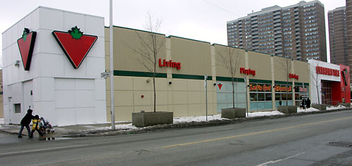
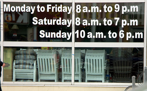
Of the six sections of the facade, four are supposed to be view-through or display windows. Of those four, one is completely obscured with white plastic film and two more are partially covered. The one remaining section that remains a true view-through window offers an uninspiring view of the backs of some chairs:
Overall, I definitely don’t get the impression of “smaller retail bays” from this storefront. In fact, I pretty much see a “continuous wall of precast concrete” that this was supposed to be an improvement on.
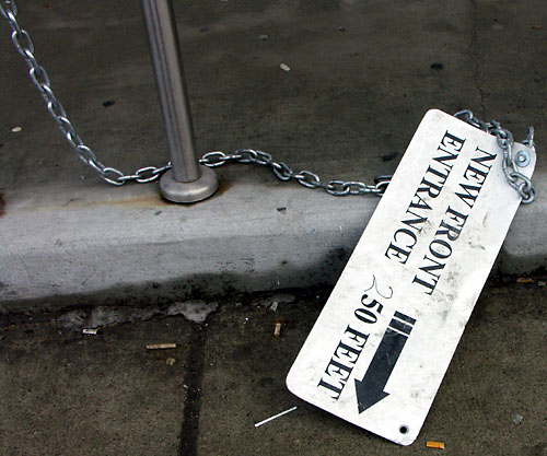
The street entrance was closed for several months starting last autumn, forcing pedestrians to enter through the parking lot entrance near the very back of the building. The sidewalk entrance was only re-opened earlier this month, though the chain and sign remain on standby, ready to close off the entrance on a moment’s notice. The handwritten correction on this sign is close to the truth: when this sidewalk entrance was closed, the only way into the store was to walk about 50 feet west, and then an additional 250 feet south to the parking lot entrance at the back of the store. “New front entrance” indeed. Just to pile on the insult, you have to walk past yet another perfectly functional door to get to the “front entrance.” I guess it’s more important to use your doorway as a shovel showcase than for, say, letting people into the store.

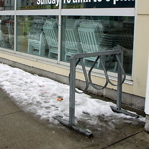
I was unable to find any bike parking on-site when I visited last week. This week, the bike rack emerged from the pile of snow by the store entrance in the parking lot. Not only is this rack in pretty poor shape, but it’s the kind designed simply to hold a bike upright, not really to lock up to securely.
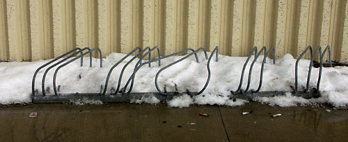
I thought these things went out with the 80s. There’s a second identical rack beside it, but in much better shape. I suppose that together, these two racks meet the requirement for bike parking. There are two lonely post and ring stands on the sidewalk in front of the store, along with this forlorn three-bike rack on the sidewalk, probably installed illegally:
What about the garden centre?
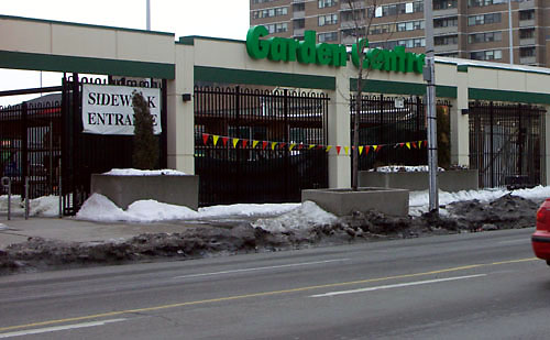
I suppose that could be called “decorative fencing,” in a “medium security chic” kind of way. There’s not much of the promised landscaping to be seen. Yes, there are scraggly trees in big concrete boxes, but I don’t really think of that as landscaping. Note the large vinyl “sidewalk entrance” sign. That’s the thing about entrances on the sidewalk — they’re so hard to find that you have to point the way to them.
This display area connected to the garden centre faces Danforth and is probably the most visible part of the store to both pedestrians and drivers. It was kept up for for a couple of years before being relegated to storage duties. Even during the gardening season, this is mostly used for storage, not retail display.
Despite the prominent streetfront location, the entire side of the building facing Danforth is very obviously the back of the store as far as Canadian Tire is concerned.
The sad thing is that all of this is really not much worse than the old store. The most prominent feature of the old storefront was a big garage door for vehicles to enter the service bays. Pedestrian access from the street was up a flight of stairs hidden behind a massive, mostly unused concrete deck. The display windows at the sidewalk were about six feet off the ground, requiring you to crane your neck to look up at the fishing rods and tools on display that week.
Landscape Architect David Leinster of The Planning Partnership presented his group’s recommendations for the future management of Crothers’ Woods at a public meeting last night. The meeting was attended by about 30 people, less than half of the number that attended the initial consultation in November. I suspect the lower turnout was because the meeting wasn’t widely publicized — I only found out about it from a post on the Don Watcher blog and couldn’t find any mention on the City’s web site.
Crothers’ Woods is an environmentally sensitive area in the Don Valley bounded roughly by Pottery Road & Bayview Avenue to the south, the CP tracks to the west, Millwood Road to the north, and the Don River to the east. Although it has no formal access points, it is a very well-used park. Identified users include hikers, dog walkers, trail runners, orienteers, school groups, and birders, but mountain bikers are the primary users of the park by far. They have created an astounding array of trails complete with ladders, teeter-totters, and other constructed elements to make the trails more interesting and challenging. Unfortunately, they’ve also created a looming ecological problem because the current trail system increases soil erosion and instability.
The primary issues that the master plan addresses are restoring the natural environment where it has been degraded by human activity and invasive species, and mitigating the further negative effects of human activity. It sets out a variety of common-sense measures to meet these goals, including native species plantings and “manual” plant control (which I took to mean “weeding”).
As for the trails, they’ll be realigned in many places and closed in the most sensitive or degraded areas. Of approximately 10 km of existing trails, 1.8 km are slated for closure. The rest will be realigned along natural contours of the land where necessary and will be managed along sustainable trail building principles as identified by the International Mountain Bicycling Association.
Also included in the plan will be new directional and wayfinding signage on the trails. This will help cyclists like me stay on the beginner trails and go in the right direction at a fork in the trail. Access to the park will be upgraded from about 10 informal access points to a half-dozen formal trail heads with information kiosks, community bulletin boards, trail maps, and other information. Two of these trail heads, at the base of Pottery Road and behind the Loblaws on Redway Road, will include parking.
Most of the above is non-controversial. The same can’t be said for the plan to close off access to the area known as “the Flats.” A Don Watcher entry provides some background detail about the Flats, including pictures. The study identified this area as among the least ecologically sensitive, so why is it being closed off? It’s all to do with the railway. The area is in a bit of a no-man’s land, requiring users to cross the CN tracks that run along the bottom of the Valley. Unfortunately, the crossing is illegal. CN has been unresponsive to the idea of installing a legal crossing in the area, so the architects of the master plan felt they had no choice but to cut the Flats off from the rest of the park.
End of story for the Flats? Well, it could have been if not for the public consultation. A couple of people at the meeting asked why it wasn’t possible to put bridges across the river, joining the Flats to the main paved Don pathways near Beechwood Drive and Don Mills Road. This would effectively do away with the troublesome railway crossing and enhance access to the Flats.
The answer from the City’s representative, Garth Armour, was that it had simply never occurred to them. He added that he’d look into the possibility, and that there might even be money in the budget for it. So the Flats may be saved after all.
I mention this incident not to condemn the City or the master planners, but to underscore the value of public input into the process. Sometimes, it takes an outsider to point out a painfully simple solution to a room full of experts. It’s not that the experts are stupid, it’s just that the process can become so focussed on one aspect of a problem (how to join the Flats to the rest of Crothers’ Woods across the railway tracks) that they can’t easily see an external solution (join the Flats to the rest of the Valley park system instead).
I’ve been in similar situations myself, where a group of like-minded professionals are concentrating on solving an intractable problem. Then someone else comes along with a dead-simple suggestion and we feel like complete idiots for not seeing the obvious. It’s the professional equivalent of ranting at technical support because your computer is broken, only to discover that you forgot turn your monitor on.
We won’t know until the final master plan is delivered to the city in a few weeks whether the bridge idea or some other idea for the Flats is considered feasible. Either way, implementation of the plan is slated for 2008.