Secure bike parking in downtown Kitchener

The new parking garage at Charles & Benton in downtown Kitchener has a secure bike parking corral. Similar to Toronto’s bike stations,  Kitchener has two of these facilities downtown now with at least one more planned. Where access to Toronto’s bike stations comes at the cost of a daily fee or monthly membership, Kitchener requires only a one-time $10 deposit.

My hotel last weekend was directly across the street from the Charles & Benton facility, so I thought I’d give it a shot for locking up even though the city doesn’t recommend using the secure corrals for overnight storage. I’d rather take my chances in a secure facility than leave my ride in the hotel’s bike rack tucked away in the darkest corner of its own parking garage. By the time I picked up my pass at City Hall and wheeled over to the garage on Friday afternoon, the sun was out and it was a gorgeous day, in contrast to the mudstorm I’d ridden through just a couple of hours earlier.

Here’s a quick look at the still-shiny-new garage and corral. Cyclists get a separate curb cut and ramp into the garage (between the bollards on the right side of the picture), so there’s no waiting in line with cars or squeezing around lift gates:

Secure bike parking corral in downtown Kitchener


Here’s the sign at the front of the secure corral, showing cyclists how to use it and how to get access:

Secure bike parking corral in downtown Kitchener


Here’s my bike, complete with stylishly dangling shopping bag, ready to be locked up while I go spend the afternoon on the town:

Secure bike parking corral in downtown Kitchener


Here’s a sign assuring cyclists that the crowding problems will soon be alleviated. It was unclear to me if the promised additional racks were already in place or if there were more yet to arrive:

Secure bike parking corral in downtown Kitchener


And here’s a shot of my bike locked up among all the others in the corral. This was as crowded as it got all weekend long:

Secure bike parking corral in downtown Kitchener

This was 3 p.m. on Friday. Granted, the rain earlier in the day may have kept some people from commuting by bike, but I confess that I expected to see a few more bikes than that. I do know that at least one other person was in there over the weekend because he or she left a water bottle resting upright on the floor beside one of the racks on Sunday morning.

I’m always deeply appreciative of all kinds of good cycling infrastructure—not just bike lanes—and get a little alarmed when it seems underused. If facilities like this are frequently empty, it’s much harder to make the case to maintain them, never mind install more of them. With a rock music festival going on just a block away all weekend, I was keenly aware that my little bike was taking up the equivalent of five parking spots for cars. I’m assuming that the seeming lack of use was from a combination of the weather discouraging cyclists that day and the newness of the lockup which has only been open for a couple of months. Getting access also requires in-person registration during business hours a few blocks away at City Hall. There are a lot of bikes in Kitchener and I’ve got to think that it’ll be more heavily used as word gets out and more people register. I also think that the two big hotels within one block of this new garage should partner with Kitchener to publicize it and make it available to guests on a short-term basis as part of their room fee.

Guelph to Kitchener

The road from Guelph to Kitchener

The farm-lined road to Anywhere, southern Ontario.

First, a travel tip for anyone taking a bike into the York Mills GO terminal: the canonical way to get to the bus platforms is to go into the York Mills Centre at the northeast corner of Yonge and York Mills, take the well-hidden elevator up to the second floor, and then walk down a short flight of stairs. It’s not so bad on foot, but it’s an overly complicated two-step when you’re swinging a loaded bike around. It’s way more convenient to ride just a few more metres north up Yonge to the same portal that the buses use and ride in through that as if you owned the place. It’s not only a shorter and easier route to the platform, but it means you don’t have to shoulder your bike down stairs or make everyone in the elevator miserable. It’s also far safer. You won’t be riding into a fare-paid zone, so it’s not like you’re doing anything underhanded.

I made a multi-modal trip to Kitchener this weekend (I’ll write more about that in the future), taking GO Transit to Guelph and cycling from there to Kitchener on Friday morning, and then reversing the trip on Sunday evening. Riding the roughly 28 km from Guelph to Kitchener is unlike riding in the countryside anywhere near Toronto. Oh sure, you’ve got the same corn fields, roadside ruminants, sod farms, rural communities, and quiet country roads, but the terrain is remarkably flat. There were only two noticeable hills for the entire ride and even those were smaller than climbing up Danforth from Coxwell to Woodbine. I’m used to traversing the Oak Ridges Moraine or climbing hills on hills on hills in the Peterborough drumlin field when I ride in the country, so riding somewhere flat is quite a treat.

Highway 7 provides the shortest and most direct route between the two cities, but it’s not very pleasant to ride on. A more southerly route along Wellington 124 is about 5 km longer but it’s at least 10 km nicer to ride on. I took a middle way to Kitchener that had theoretical advantages over taking 124: the route along Fife Road is both quieter and shorter by almost 3 km. It also has a long stretch of riding on dirt roads, which doesn’t usually bother me. It would have been perfect if I hadn’t been riding in Friday’s rain, which begat mud, which begat a poorly functioning drivetrain, which begat sucking the fun out of the ride. I was insanely happy that my hotel room was ready three hours before check-in time. “How are you today Mr. Dodge?” “A little muddy.” “I see that.” In total, the ride from downtown Guelph to downtown Kitchener was 28.5 km and took 90 minutes in the rain with a malfunctioning rear derailleur that left me more or less stuck in an awkward gear.

Sunday’s evening’s return trip was sunny and warm (see the picture above) with a steady tailwind. I took advantage of the tailwind to ride the slightly longer return route along Kossuth Road and Wellington 124. Both of those roads have nice wide paved shoulders for most of their length and are easy to ride on if not quite as scenic as some of the quieter rural roads. The return trip was 30.5 km in just 75 minutes with a tailwind blowing all the way. Not bad for a loaded mountain bike. I’d recommend the Fife Road route if it’s dry and you don’t mind riding on dirt roads. I don’t think I’d do it on my road bike. If you want a smooth ride that’s relatively fast but with less traffic than Highway 7, take Wellington 124 and Kossuth Road. You’ll have to head either north or south to cross the Grand River into town; take whichever way is the shorter route to your ultimate destination.

If you’re so inclined, you can read a more detailed ride report below the fold.

Read More …

Public bike repair stands

I was riding downtown a couple of weeks ago and decided to pop my bike up on one of the newly installed public bike repair stands to give it a quick once over:

Old Faithful on a public bike repair stand.

Each of the three stands downtown (plus one more on the university campus) includes a full set of tools for most basic on-the-go repairs and adjustments:

Tools available at the public bike repair stand.

The stands even feature bike repair videos and tips, via a QR code that links to a helpful website.

QR code for bike maintenance instructions on the public repair stand.This is the kind of cycling infrastructure that I love: it’s incredibly useful for both casual and seasoned riders and just sits unobtrusively in the background until it’s needed. The only thing missing from the stand is a pump, which is probably the one tool that would be used the most. Susan Sauvé, a transportation planner at the city, told me via email that pumps were originally included with the stands when they were installed in July, but they all broke within a week. The city currently has more durable pumps on order from the manufacturer and hopes to re-install them soon.

My bike checked out fine on this occasion, but I definitely could have used one of these stands when my pedal broke near Grange Park last year and I needed to conduct some emergency repairs before finishing my commute. It’s good to know that if it happened again today, I’d be just a short 163 km ride away from this stand at the corner of George and Simcoe Streets in downtown Peterborough. The two other downtown Peterborough locations would be a smidge closer, and the one at Trent University a bit farther. The stands were installed this summer through a partnership of the City of Peterborough and B!ke, a local DIY bike repair shop. Oh, you didn’t think these were in Toronto, did you? Doncha know there’s a war on the car here? The last thing we want to do is make things easier for those dastardly bikers.

Peterborough to Hastings rail trail


The Peterborough to Hastings rail trial curves away from the Trent River after kissing the shore.

After our thoroughly enjoyable trip on the Peterborough to Omemee rail trail a few weeks ago, I decided to take a trip down a second Peterborough-area rail trail this weekend, heading east out of town this time. Risa was unable to join me for the ride, so I packed up my day-trip kit and did this one solo.

The Peterborough to Hastings rail trail is not yet part of the Trans Canada Trail, but is listed as a proposed addition and there is some work afoot to make it official (PDF) and make improvements where necessary. As it stands now, the trail is formally maintained only in winter as a snowmobile trail, leaving summer maintenance to volunteers acting on an ad hoc basis with no coordinating body.

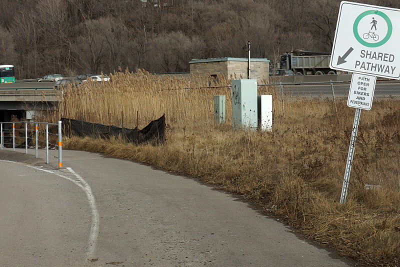
Compared to the Peterborough to Omemee trail, the lack of coordination shows: the route to Hastings is a little more wild and a bit more of a challenging ride. Unlike the smooth wide bed of gravel dust on the Omemee trail, the ride to Hastings is mostly on dirt double-track with some large gravel, loose sand, and other trail hazards along the way. Some of the bridges seemed to be in rough shape, with some surface planks rotting away and exposing holes big enough to see through to the rivers below. The trail is probably smooth as butter when it’s covered with a couple of feet of hard packed snow but it can be a little jarring on a bike in the summer. It’s certainly in good enough condition and offers enough variation for an average cyclist to have an enjoyable trip, but you won’t find any beach cruisers on it. Front suspension on my mountain bike was most welcome by the halfway mark.

The trail was exceptionally quiet considering that it was a beautiful Saturday afternoon for cycling or hiking. The first 90 minutes of my two hour putter along the trail were blissfully solo, without another soul in sight at any time, even when crossing intersections. The last half hour was almost as quiet and I only encountered four people on the trail before I turned onto the streets of Hastings. I imagine that it’s not quite as tranquil when the snowmobiles hit the trail, but it’s a very relaxing summer day trip.

The trail ends somewhat unceremoniously in the middle of the Trent River in Hastings (see the gallery below for more information about that), but you can make connections from there to other trails that continue to Campbellford, Tweed, and Sharbot Lake. Traversing gaps to yet more trails that can get you as far as Bancroft or within hailing distance of Bon Echo Provincial Park.

The Peterborough to Hastings rail trail starts approximately 7 km southeast of downtown Peterborough at Keene Road and runs about 29 km to Hastings. Like most rail trails, it’s fairly flat and grades are slight enough that they won’t trouble even the most casual of cyclists. The scenery ranges from wide-open farmers’ fields to thick forest growth and includes views of numerous rivers, creeks, marshes, swamps, cows, and even a couple of trailer parks heading into Hastings. Intersections are mostly quiet dirt roads. There are no obvious supply facilities or rest stops along the way other than farmhouses that back onto the trail; the village of Keene is about 2 km south of the trail at the 9 km mark, but that’s about it. Be sure to pack a repair kit and adequate food and water.

Check out the gallery after the jump for the usual ride pictures and commentary.

Read More …

Peterborough to Omemee rail trail

This is why I don’t understand why people pay to ride stationary bikes in windowless gym basements.

Risa and I rode the 22 km from downtown Peterborough to Omemee this weekend via an old railway that’s now part of the Trans Canada Trail. Starting from its origin in Peterborough, this rail trail runs between backyards and along a small stream before quickly leaving the city, pavement, and crowds behind on the way to Omemee and beyond.  It has everything you’d expect along the way: scenic vistas, a well-maintained gravel bed, planked-in bridges and trestles like the one shown above, and an utter lack of traffic and hills. The trail continues past Omemee to Lindsay, where you can connect to other trails that will take you to Uxbridge, Fenelon Falls, or all the way up to Haliburton.
Peterborough to Omemee rail trail
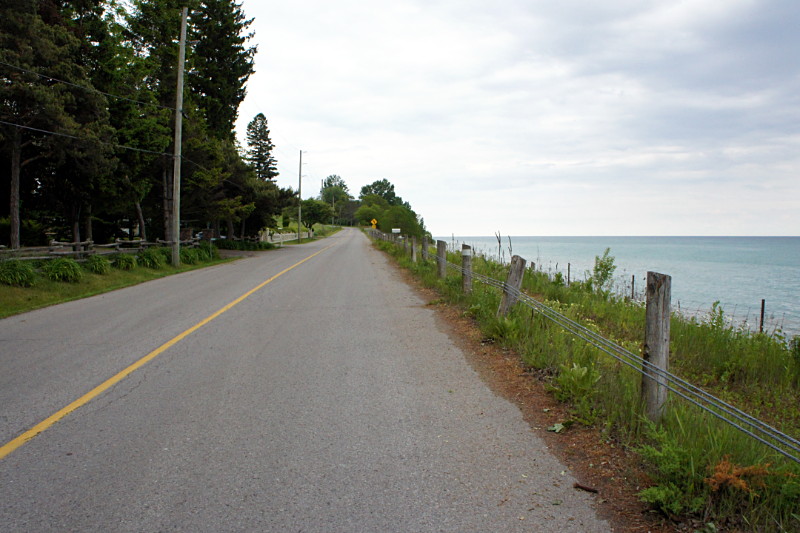
The trail is an easy and relaxing ride for the entire length. It passes a few rural intersections and driveways at grade, while busy Highway 7 and some other driveways are carried over the trail on bridges. The urban intersections in Peterborough are similar to the ones on Toronto’s Beltline, but have curb cuts to actually let cyclists cross at the trail. The trail itself is well-maintained and can be ridden by the most casual of cyclists. Along the way you are treated to views of farms, valleys, and the rolling hills that you are not constantly climbing up and down. That’s the real joy of rail trails: you may be climbing, but the grade is so slight that it doesn’t hurt when you’re going up and it’s like having a slight tailbreeze when you’re going down.

Check out the short gallery with some of the sights along the way after the jump.

Read More …

Two roads, one day

The first ever Bells on Danforth ride pauses at Pape.

Mid-afternoon on Saturday: The first ever Bells on Danforth ride pauses at Pape.


Lakeshore Road outside Newcastle, Ontario.

Early evening on Saturday: Lakeshore Road outside Newcastle.

Saturday was a day of contrasts and lots of fun bike riding. In the morning, I was helping to set up the skills course for the Ward 35 bike rodeo in Scarborough. By mid-afternoon, I was cycling to Queen’s Park very slowly with 90 other cyclists as part of the inaugural Bells on Danforth ride. And in the early evening, I was pedalling down a virtually deserted Lakeshore Road on Lake Ontario between Newcastle and Port Hope. After cycling out of Newcastle and before arriving on the main drag of Port Hope 90 minutes later, I encountered a scant eleven cars and three pedestrians—and none at all of either for a full 45-minute stretch. With the sun finally peeking out from the clouds for the last half hour of my ride, it was the perfect way to unwind from a long day of good cycling and lousy weather.

Bike Month

Most people who read this blog will already know that Bike Month kicks off on Monday with the Group Commute to City Hall. But you may not know about two other biking activities taking place in June that I’m helping to organize through my work with Ward 29 Bikes:

  • Bells on Danforth. Inspired by Bells on Bloor, Bells on Danforth will be a fun—and with luck, huge—group ride on Saturday, June 2 from East Lynn Park (south side of Danforth, one block west of Woodbine) to Queen’s Park for the Cycle and Sole rally. We’ve been talking about organizing this ride for years and we finally got it off the ground this year by joining forces with the other east end cycling groups—32 Spokes, SoDa Bikes, and DECA Bikes—along with a lot of help and advice from Peter Low of Bells on Bloor. We have no real idea how many people to expect on the inaugural ride but I’m hoping for at least 200.
  • Thursday night rides. At Ward 29 Bikes, we’ve also talked about running social rides for almost as long as we’ve been around (since 2008!) but we’ve never quite gotten around to actually doing it until this year. We’ve organized a slate of four rides on Thursday evenings in June, leaving from the East York Community Centre and tootling around various parts of the city for 90-120 minutes. I’m hoping for 10-20 people on each ride. I’ll be on all of them, so set aside a couple of hours on one Thursday in June if you’ve ever wanted to heckle me in person.

Worst bike name ever

The MEC created a minor stir a few weeks ago when it announced that it would start selling Ghost bikes, a brand long-established in Germany but whose name means something else entirely here. It would have been difficult to find a bike name less suited to the North American market, but then I found the Ibis Tranny:

Ibis Tranny bike

The Ibis Tranny has both a monocoque frame and a slot machine. Good to know.

It raises the inevitable question: would you rather be caught hammering a Ghost down the trail, or riding a Tranny? Either way, I’ll stick to my Trek, thanks.

Same path, same day, different rules

In Taylor Creek Park near the forks of the Don, a raised pathway was installed a while ago so that pedestrians and cyclists wouldn’t have to contend with vehicular traffic on the park roadway. When you’re heading east into the park, the shared path beckons to cyclists, explicitly declaring that it’s “open for bikers [sic] and pedestrians”:

Welcome, eastbound cyclists.

But at the other end of the path, cyclists heading west out of the park are sternly instructed to dismount:

Go away, westbound cyclists.

To be clear, this is the same “shared pathway,” only about 100 metres long, and built with the express purpose of giving safe passage under the Don Valley Parkway away from cars on the park road. And although it’s signed as a shared pathway at both ends, it seems that only eastbound cyclists are actually allowed to ride their bikes.

If the pathway is too narrow to allow cyclists to ride in both directions while mingling with pedestrians (an assessment I wouldn’t disagree with), or if there’s a blind corner that makes riding full-bore unsafe, why weren’t those issues addressed during design and construction? Or better yet, why not just mark it as a pedestrian walkway and encourage cyclists to just take the road, which is the route still chosen by the vast majority of cyclists anyway?

Ironically, the raised path would be of most use to westbound cyclists because it doesn’t dip as low under the bridge as the roadway does, making the short hill on the far side easier to climb. Yet it’s westbound cyclists who are singled out for dismounting. Personally, I think that if the city wants this passage to be safer, it should instruct drivers to get out of their cars and push. After all, there’s a blind corner and the lanes are a little narrow…