Recycling nostalgia

Consumers Distributing display casesI’m usually one to appreciate and advocate both recycling and heritage preservation, but I’m not so sure it’s a wise move in the case of these display cabinets still in use in a Port Hope store. I remember Consumers Distributing as an eminently frustrating place to shop. Cheaper than department stores, but impossible to tell whether anything was in stock or see any merchandise without filling out a little paper slip.  Couple that with waiting in line for somewhere between five and thirty minutes before being disappointed, and going to Consumers was always a bit of a crapshoot, a problem that only seemed to get worse as I got older. Still, the local Consumers at Main and Danforth was the primary supplier of AFX slot car sets and Timex watches to my youth.

End of the Road: Steeles Avenue East. Really, really East

It’s not called Steeles Avenue all the way out here (we even left the street’s other moniker, Taunton Road, behind a long time ago), but if you start at Yonge Street and travel east for 79 km on the same road across the top of Toronto and through Pickering, Ajax, Whitby, Oshawa, Taunton, Hampton, and Orono, you eventually end up on Concession Road 6  just past Gilmore Road, looking at this sign and wondering if your car has better traction than farm equipment. The answer? The road is fine for a little while, but a soft and sandy stretch was enough to turn me back today. I would have investigated the extra half-block, but I was both bikeless and time-constrained. That’s the problem with exploring in a car: you’ve definitely got more range, but it’s much harder to make detours. Also, if your car gets bogged down in mud, you can’t just throw it over your shoulder and carry it back to more solid ground.

Transporting Dodgeville by the numbers, 2009

Overall distance travelled (km): 18,685

  • by airplane: 6,083
  • by bike: 5,395
  • by car: 4,840
  • by foot 1,319
  • by train: 688
  • by TTC: 294
  • by non-TTC transit: 49
  • by horse: 8
  • by Ice Explorer: 6
  • by canoe: 3

Days I walked: 319
Days I rode my bike: 275
Days I was a passenger in a car: 41
Days I drove a car: 25
Longest ride ( km): 154.4
Shortest ride (km): 2.22
Times I needed rescue by car: 1
Rides longer than 100 km: 5
Rides 10-20 km: 184
Rides shorter than 10 km: 18
Days I rode without a helmet: 1
Flat tires: 2
Tire blowouts: 1
Broken chains: 1
Broken derailleurs: 1
Broken bells: 2
Broken pedals: 2
New wheels: 3
New drivetrains: 2
New brake pads: 6
Bottles of Ice Wax lube: 3
Bikes I currently own: 7
Bikes I actually rode last year: 5
More bikes I want to buy: 2
Chance that I’ll convince Risa that I need to buy more bikes: 0

At the beginning of 2009, I embarked on a year-long project to record the distances I travelled by various means of transportation. I expected cycling to come out on top by a wide margin. My mileage estimates a year ago were 5000 km by bike, 2000 km by car, 1000 km on foot, and 500 by TTC. I got the order right, but some of the numbers were way off. In particular, I hadn’t anticipated flying anywhere, and my car mileage was bumped up considerably by our (ultimately successful) hunt for a cottage this fall; two months accounted for more than 2600 km of the 4840 km total I spent sitting in cars, and 1300 km of that came in just four days of visiting, revisiting, and inspecting.

It’s a lot of work keeping track of everywhere you go for a year. The spreadsheet I used to record every trip is 787 lines long, with calculations being done on a separate sheet before being uploaded automatically every night to my web server. My cycling log will continue to survive into the new year (as it has every year since 1991), but I think I’ll be dropping the rest of the tracking.

Dodgeville does the Icefields

icefields-parkway-08951s

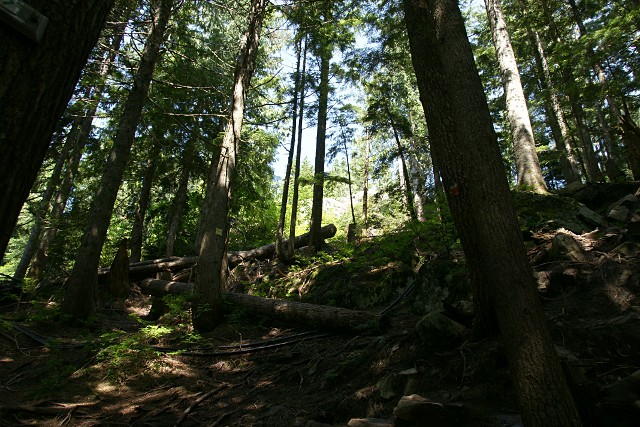
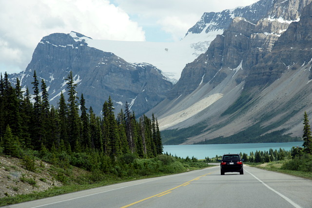
After our couple of days in and around Jasper, we headed south down the Icefields Parkway toward Lake Louise. I’ve been on some really nice drives, including the Pacific Coast Highway between San Francisco and Monterey, and the Icefields Parkway is by far the best I’ve done.  Rarely do I actually want to pull over at every single lookout, but they were hard to resist on this trip.

When you’re driving down the Icefields Parkway, you have to make a decision: are you driving to your destination on a rough schedule, or are you taking pictures of all of the interesting things along the way? You have to make this decision whenever and wherever you’re on vacation, but Jasper is so filled with photographic opportunity that the choice must be made over and over again. I sometimes need to remind myself that I’m on vacation and not on a photographic expedition hunting for the perfect exposure of the most awe-inspiring vista. I know that it can be boring (at best; supremely annoying at worst) to travel with someone who’s constantly setting up a tripod, micro-adjusting focus and frame, running around with a light meter, and waiting in one spot for ten minutes for the wind to die down or the light to be just so. This picture is a perfect example of the tension between enjoying a relaxing vacation and satisfying a photographic vision:

icefields-parkway-08692s

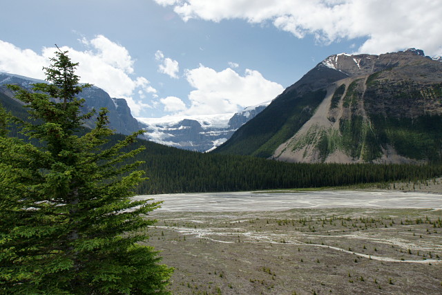
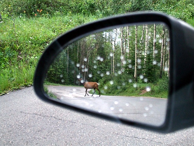
There was a very large raven sitting right on the top of that tree at the left. Several of them, in fact. One would fly away and another would take up the perch immediately afterward. So I got into position, tree in the foreground, mountain in the background, broad valley in between, a bright blue sky with fluffy white clouds filling in the blanks. Took a couple of test shots and selected my preferred exposure. But now that I was in place with the viewfinder pressed to my eye, finger on the shutter button, and everything framed perfectly, the ravens were all hanging out elsewhere: in the parking lot, in another tree, on the rocks, in the sky, anywhere but sitting on that damned tree. If I’d been here alone, I would have stood there and waited half an hour for a raven to return to the top of the tree and give me the picture I had already composed in my head. But looking over at Risa getting restless at the car, I knew my time was up. Fifteen minutes at a single lookout was enough. So there’s the picture, and not a raven in sight.

But that’s okay, because in Jasper, there’s always something else around the next corner. And Risa didn’t know it yet, but we were on a mission to trek out onto the Athabasca Glacier. All the whining in the world didn’t get me into one of those icemobiles when I was nine years old, but now that I’m old enough to pay my own way, nothing’s going to stop me. That’s the best part about growing up.

icemobile-mk3-08759s

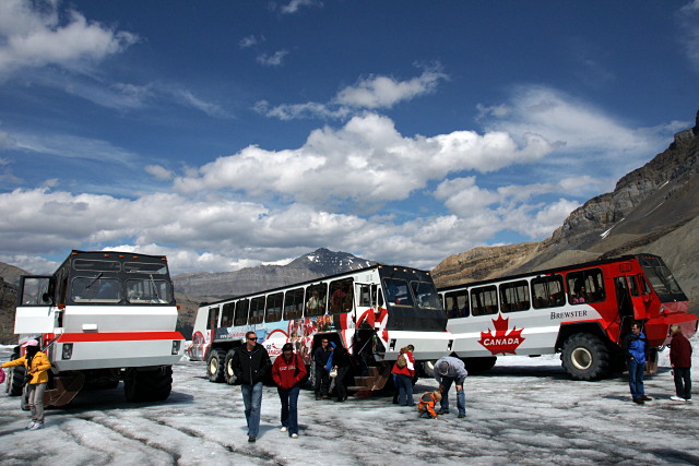
So onto the glacier we went. It was the perfect cap to an amazing drive through the mountains. There’s more about the glacier in the inevitable gallery at the end of this post. Suffice to say that it was impressive in every way.

Don’t tell Risa, but when we were planning our Western trip, I’d seriously considered trying to include some kind of cycling component between Jasper and Banff. If the Icefields Parkway is supposed to be a really nice drive, it should be an even better ride, no? Well, possibly. But passing dozens of riders on supported tours slowly grinding up one hill after another made me glad that I’d silently shelved the thought. Oh, I’m sure that I could have finished the ride, but I doubt that our marriage would have survived the 300 km trek.

On to the gallery and more observations.

Read More …

Tour de Kennedy

hay-field-3423f

How long does it take to ride up Kennedy Road to Lake Simcoe? Almost two months, apparently. As I mentioned before, it took three attempts (and two bikes) starting at the end of June for me to complete this trip. Kennedy Road is an interesting contrast to Warden, just two kilometres to the west and my more usual route north: Kennedy seems much more wild, with fewer farms and estate houses, and more forest and overgrown meadows. Kennedy also has less industry than Warden, fewer golf courses, and less traffic. The downside is that it’s also somewhat poorly maintained, with many kilometres of the road through East Gwillimbury cratered with potholes and only haphazardly patched in a way that makes it rather bike unfriendly. Still, it’s a very peaceful ride. The landscape feels less constricted than on Warden, with several sweeping vistas that you don’t see from the other northbound routes.

country-mile-lane-3815f

One of the things that I like most about riding out of the city is watching streets take on completely different characters. Two of my formative years were spent not too far from the foot of Kennedy Road in Scarborough, where it’s a sleepy residential street. Most people are familiar with the big box hell of Kennedy Road from Lawrence to Sheppard. That’s followed by the suburban thoroughfare of northern Scarborough and Markham, which gives way to a quiet concession road and a lazy country road before finally ending up at a beach in a little cottage area. It may all be one street, but it has at least eight distinct phases from beginning to end.

Before these rides, the only part of Kennedy north of Sheppard that I’d ever ridden on was the 400 or so metres between Ravencrest Road and Mount Pleasant Trail, where it forms part of a nice big diagonal shortcut from Woodbine to McCowan on the way to Sutton.

Read on for the full gallery treatment of my ride up Kennedy Road.

Read More …

Dodgeville takes the train to Jasper

train-to-jasper-07884s

Leaving Vancouver behind, we took the VIA Rail Canadian to Jasper. I love trains, but even I have to admit that spending more than 18 hours on a train is pushing my limit. At least one family in economy with us was going all the way to Toronto, a four-day journey. My head hurts just thinking about it.

I’d happily take the train across the country, but I could never do it all at once. I’d get a 30-day pass (or, thanks to VIA’s somewhat limited fare structures, two or three 12-day passes) and hop across the country a few hours at a time, spending a day or two here and there to explore. Four days all at once? I can’t imagine.

Still, I highly recommend the train trip from Vancouver. The train crosses much of the B.C. interior at night, and spends most of the following day crisscrossing the Fraser River and North Thompson River valleys and eventually climbing over the Yellowhead Pass into Alberta.  By my count, our train had at least 17 passenger cars (including 6 cars with observations domes), making it by far the longest train I’ve ever been on. The observation car nearest to us was never more than half full when we went up there. My advice: try to get a good night’s sleep at the beginning of the voyage and then grab a good window seat for the rest of the day, whether in the dome car or your regular passenger car. If you can, shell out for a sleeper compartment; it’ll cost twice as much, but you’ll be at least three times happier in the morning.

Jasper, the National Park, is nothing short of awe-inspiring. You could probably spend the entire summer there and not run out of places to go or things to see. Jasper, the town, is tiny and reminds me a lot of southern Ontario tourist towns: the main drag is so focused on serving tourists that I’m always left wondering where local residents shop or eat. I can’t imagine that locals spend $100 for a middling dinner for two at Evil Dave’s or $20 for souvenir underwear.

elk-in-the-mirror-3542f

I love little local museums, and the Jasper-Yellowhead Museum didn’t disappoint. The walkthrough display chronicling Jasper’s history is so chock-full of Banff-envy that it reads like it was penned by a spurned lover. “Banff may be bigger and better, but we’re happy that we’re small and unappreciated! We swear!” While the museum spends a lot of time disparaging the development and popularity of Banff and extolling the quiet virtues of still-wild Jasper, it’s actually bang-on in making the comparison. Wildlife was abundant in Jasper, with appearances by too many elk to count, as well as some deer, a moose, a black bear, and countless ravens that seemed twice as big as their urban cousins in Vancouver.

Just about the only thing I remember about Jasper from when I was there as a kid thirty years ago was the preponderance of trailers and motorhomes. It’s still largely the same, but at least half of them these days are rentals.

Anyway, read on for the obligatory gallery and more observations.

Read More …

Dodgeville annexes Vancouver

Kayaking on False Creek

The best thing about taking a vacation is coming back home. Don’t get me wrong, I always enjoy exploring beyond the normal boundaries of the Greater Dodgeville Area, but there’s just something about Toronto that really makes me appreciate coming back to it.

Risa and I were visiting family in Vancouver before scooting over to Jasper and Banff for a few days. It was a varied couple of weeks for transportation: in all, we flew, drove, walked, hiked, biked, and canoed, and rode the train, the bus, the icemobile, the ferry, and horses: something different almost every day.

This was the third time I’ve been to Vancouver in the last five years, and my first trip to Alberta since I was nine years old. I’ll spare you the typical vacation slideshow here, but I thought I’d share some random Dodgeville-style observations from each place we visited, starting with Vancouver. Banff and Jasper will follow in subsequent posts.

Read More …

Grouse Grind

Risa and I are on vacation out west. I used the occasion to climb Grouse Mountain, one of the peaks overlooking Vancouver. The interesting thing about Grouse Mountain is that you can take public transit to it: a quick ferry and bus ride  from downtown Vancouver gets you right to the base of the mountain for $3.75. Ah, for TTC and GO service like this to some of Toronto’s far-flung attractions. Grouse Mountain isn’t huge by mountain standards, but it’s still a lot bigger than anything I’ve climbed in Toronto. I’ll have more random thoughts about Vancouver in a later post or two, but for now, here’s a gallery of my climb up the Grouse Grind.

Tour de Dufferin

Moo! These cows are really friendly to people who stop by for a visit.

There’s a lot to see on Dufferin Street before you get to the end of the road. Once you get out of the city and past the worst of suburbia, the street progresses through several distinct and varied phases as it marches north through horse farms and wooded valleys before running out of space in the heart of the Holland Marsh.

I started my trip (two trips, actually; one in a chilly rain and the other in glorious warmth and sunshine) at the TTC’s Downsview station, riding through a quiet industrial area before hopping onto Dufferin at Steeles and riding as far north as I could go.

Until I made this ride, I’d only ever seen Dufferin north of Steeles a handful of times, and always on my way to or from Pardes Shalom Cemetery (and once almost 20 years ago when I went to Eaton Hall for a wedding). I wasn’t expecting much, but was pleasantly surprised to find that the worst of the sprawl is, for the moment anyway, contained to the south of the cemetery and that the countryside really opens up to the north, allowing Dufferin to retain its rural feel.

The relentless march of suburbia to the south finally melts away into farmland as you pass through Vaughan

I’ll also add that we must have had a really good spring and summer so far because all of the vegetation—whether wild or farmed—was greener and lusher than I remember seeing in a long time. I wanted to stop for pictures almost constantly, which isn’t exactly the best way to get home on time.

I ride outside the city fairly frequently, but this was the first time that I stuck to a single road to its end and documented the journey. I’ll be doing it a few more times as the summer progresses. The gallery below contains the highlights from the Tour de Dufferin. Enjoy.

[Note: the gallery images may not display properly from an RSS reader. Please visit Dodgeville directly to view the gallery. I’m looking for an elegant solution to this, but I’m not sure that there is one.]

Read More …

The Newmarket Canal

Standing in front of the middle lock

There’s an interesting piece of history hiding in the outer reaches of the GDA (Greater Dodgeville Area, loosely defined as any place I can reach by bike) just north of Newmarket: the scattered remnants of the Newmarket Canal.

This never-finished canal was to be a southerly branch of the Trent-Severn canal from Lake Simcoe to Aurora via the Holland River. This was not a trivial undertaking for many reasons, not the least of which was that there just wasn’t enough water in the river to operate a canal. The initial plan for the canal called for reservoirs to be fed by water diverted from Lake Wilcox, the source of the Humber River. That plan was later shelved as being too expensive and politically unpopular, and was replaced by a scheme to pump the necessary water uphill from Lake Simcoe to the top of the Oak Ridges Moraine at Aurora.

Work on the canal was to be done in three stages: the first required that the river be dredged from Lake Simcoe to Holland Landing. The second required three locks to be built between Holland Landing and Newmarket (the second of those locks is pictured above). The final phase, from Newmarket to Aurora, would require an additional five or six locks depending on the final route, which still hadn’t been finalized when construction began.

Even as the work on the canal began in 1906 and continued for five years, there was still no clear plan for keeping enough water in the canal to keep it navigable during any period of the year outside the spring thaw. Increasing public opposition, escalating costs, and a change in government ultimately doomed the project in 1912 after years of political shenanigans, interference, and scandals that would make most modern politicians blanche. At that point, most of the work on the canal through Holland Landing and up to Newmarket had been completed. The three lock structures and the base of one swing bridge that had been built before the project was called off still stand along the east branch of the Holland River north of Newmarket.

James T. Angus’s comprehensive book, A Respectable Ditch: A History of the Trent-Severn Waterway 1833–1920, details the tortuous political and physical paths of the entire project’s 90 years of debate, design, and construction. It devotes a chapter to the Newmarket Canal debacle and is well worth reading.

This was at least the second planned canal along this route. The other would have gone straight through the Oak Ridges Moraine and connected to Lake Ontario via the Humber River.

I first visited two of the abandoned lock structures almost 20 years ago, shortly after learning about the Newmarket Canal in Ron Brown‘s excellent guidebook, 50 Unusual Things to See in Ontario. I finally visited the third lock and the swing bridge just this past September.

Looking back now, 50 Unusual Things was probably what set me off on my habit of exploring the GDA and finding unusual sights and abandoned bits of the city. Damn you, Ron Brown!

My most recent cycling visit to the canal was on Saturday, during which I was trapped under a sheltering bridge for an hour and a half by that big storm that whipped across southern Ontario. I eventually called Risa to rescue me with the car after giving up hope that the lightning, rain, and wind would let up in time for me to get back home at a reasonable hour.

The irony here is that I was stuck within spitting distance of the East Gwillimbury GO station. I could easily have gone home by train, but the next one was 36 hours away on Monday morning and I wouldn’t have been able to take my bike on it. Hello GO? Weekend service, please.

More pictures below the fold.

Read More …